 Green 1910s-20s map

|

|
|
|
item:- Armitt Library : A6480.1 image:- © see bottom of page |
click to enlarge |
|
|
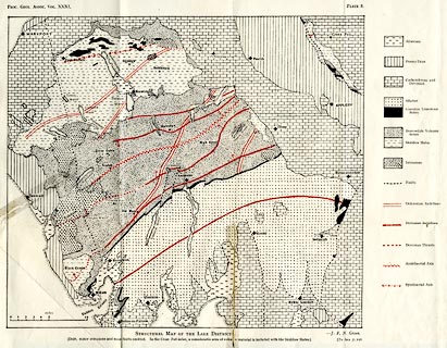
Geological map, lithograph, Structural Map of the Lake
District, scale about 4 miles to 1 inch, by J Frederick N
Green, published in the Proceeding of the Geologists'
Association, vol.31 pp.109-126 and plate 8, about 1920.
Folded and tipped in, illustrating an article, The Geological Structure of the Lake District |
||

|
Green 1910s-20s map | |
| map feature:- | folded (4x2) & table of symbols & up is N & scale line & sea plain & coast form lines (dotted) & lakes & settlements & geology & stratigraphical column | |
| inscription:- |
orinted top left, right
PROC. GEOL. ASSO. VOL.XXXI. / PLATE 8. |
|
| inscription:- |
printed bottom
STRUCTURAL MAP OF THE LAKE DISTRICT. J. F. N. Green. / ... |
|
| inscription:- |
printed with scale line
miles |
|
| scale line:- | 10 miles = 63.6 mm | |
| wxh, sheet:- | 39x31.5cm | |
| wxh, map:- | 295x259mm | |
| scale:- | 1 to 250000 ? (1 to 253042 from scale line) | |