 Hebert 1816

|

|
|
|
item:- Armitt Library : 1959.193 image:- © see bottom of page |
click to enlarge |
|
|
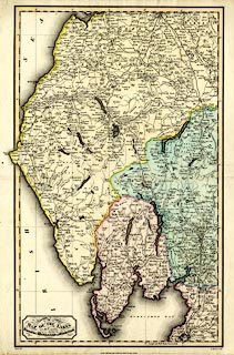
Map, hand coloured engraving, Map of the Lakes in the
Counties of Lancashire, Westmoreland and Cumberland, scale
about 3 miles to 1 inch, drawn by Hebert, engraved by H
Mutlow, published by T Cadell, and W Davies, Strand, London,
1816.
|
||

|
Hebert 1816 | |
| map feature:- | plain cartouche & up is N & lat and long scales & lat and long grid & sea plain & coast form lines & headlands & lighthouses & rivers & lakes & forests & parks & county & settlements & roads & canals | |
| inscription:- |
printed title cartouche, lower left
A MAP OF THE LAKES / in the Counties / OF / Lancashire, Westmoreland and Cumberland. |
|
| inscription:- |
printed bottom left, right, centre
Hebert delt. / H. Mutlow Sculp. / London. Published Augst. 10th. 1816, by T. Cadell & W. Davis, Strand. |
|
| wxh, sheet:- | 38x52.5cm | |
| wxh, map:- | 309x503mm | |
| scale:- | 1 to 190000 ? | |