 Teesdale 1830

|

|
|
|
item:- JandMN (450) image:- © see bottom of page |
click to enlarge |
|
|
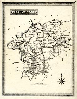
Map, uncoloured, Westmoreland ie Westmorland, scale about
8 miles to 1 inch, published by Henry Teesdale and Co, 302
Holborn, London, 1830.
Perhaps a lithograph reproduction at a later date? |
||

|
Teesdale 1830 | |
| map feature:- | piano key border & plain cartouche & compass rose & up is N & scale line & sea plain & coast tinted & rivers & lakes & parks & county & settlements & roads & canals | |
| inscription:- |
printed title cartouche, upper left
WESTMORELAND |
|
| scale line:- | 10 miles = 31.9 mm | |
| scale:- | 1 to 500000 ? (1 to 504497 from scale line) | |
| wxh, sheet:- | 17.5x23cm | |
| wxh, map:- | 149x193mm | |