 Bacon 1895

|

|
|
|
item:- JandMN (423) image:- © see bottom of page |
click to enlarge |
|
|
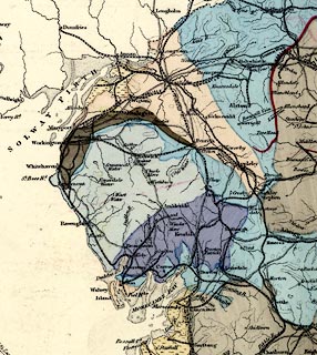
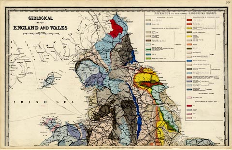
Geological map, colour lithograph, N part only,
Geological Map of England and Wales, scale about 18 miles to
1 inch, published by G W Bacon and Co, Strand, London, 1895.
Sheet 99 from the Commercial and Library Atlas of the British Isles from the Ordnance Survey. Geological areas are delimited by a fine dotted line. The colouring does not distinguish all of these, for instance - the Shap Granite is coloured as part of the Carboniferous limestone; the Coniston Limestone series is not shown at all. The bottom of the stratigraphical column has Cambrian then Silurian, no Ordovician which had been introduced several decades before. |
||

|
Bacon 1895 | |
| map feature (from N sheet only):- | piano key border & up is N & scale line & lat and long scales & sea plain & coast line & rivers & lakes & settlements & roads & railways & canals & geology & stratigraphical column | |
| inscription:- |
printed upper left
GEOLOGICAL / MAP OF / ENGLAND AND WALES |
|
| inscription:- |
printed bottom
GEOLOGICAL ENGLAND NORTH SHEET |
|
| inscription:- |
printed with scale line
Scale of Miles |
|
| scale line:- | 50+5 miles = 80.7 mm | |
| wxh, sheet:- | 53.5x34cm | |
| wxh, map:- | 511x315mm | |
| scale:- | 1 to 1100000 ? (1 to 1096827 from scale line) | |
|
||
|
||
|
|
notes | |