 Bacon c1907

|

|
|
|
item:- JandMN (377) image:- © see bottom of page |
click to enlarge |
|
|
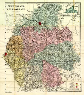
Railway map and political map, colour lithograph,
Cumberland and Westmorland, scale about 3.5 miles to 1 inch,
by G W Bacon and Co, 127 Strand, London, about 1907.
Includes part of Lancashire north of the sands. The map is in a card cover withg descriptive text, an index to places in Cumberland and an index to places in Westmorland. |
||

|
Bacon c1907 | |
| map feature:- | folded (6x4) & card cover & table of symbols & up is N & scale line & lat and long scales & index grid & sea plain & coast line & rivers & lakes & relief & hill hachuring & woods & forests & parks & county & electoral data & settlements & roads & railways & canals | |
| inscription:- |
printed upper left
CUMBERLAND / AND / WESTMORLAND / REDUCED FROM THE ORDNANCE SURVEY / Divided into 5 mile squares |
|
| inscription:- |
printed bottom left
G. W. Bacon & Co. 127 Strand, London. |
|
| inscription:- |
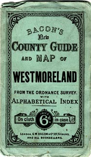
printed cover
BACON'S / New / COUNTY GUIDE / AND MAP OF / WESTMORELAND / FROM THE ORDNANCE SURVEY. / WITH / ALPHABETICAL INDEX / On cloth PRICE 6d. in case 1/6 / LONDON, G. W. BACON & Co., 127, STRAND, / AND ALL BOOKSELLERS. |
|
| scale line:- | 10 miles = 75.6 mm | |
| scale:- | 1 to 210000 ? (1 to 212876 from scale line) | |
| wxh, sheet:- | 50.5x58cm | |
| wxh, map:- | 447x524mm | |
| wxh, folded:- | 9x16.5cm | |
| wxh, cover:- | 10.5x17.5cm | |
|
||