button to main menu Tattersall 1836 map

item:-
Armitt Library : A1204.2
image:-
©  see bottom of page
image, button to large image
click to enlarge


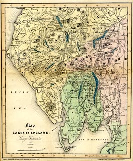
Map, coloured lithograph, Map of the Lakes of England, scale about 4 miles to 1 inch, by George Tattersall, engraved by J Nethercliff, 23 King William Street, Strand, published by Sherwood and Co, 23 Paternoster Row, London, about 1836.
Folded and tipped in opposite p.1 of The Lakes of England, by George Tattersall
   Tattersall 1836 map
map feature:- folded (3x2) & up is N & scale line & lat and long scales (rectangular projection; Longitude West from Greenwich) & sea plain & coast form lines & rivers & lakes & relief & hill hachuring & forests & parks & county & settlements & roads & sands roads & canals
inscription:- printed lower left
Map / of the / LAKES OF ENGLAND : / BY / George Tattersall. / 1836.
inscription:- printed with scale line
Scale. / Miles.
scale line:- 8 miles = 49.6 mm
wxh, sheet:- 26.5x33cm
wxh, map:- 256x306mm
scale:- 1 to 260000 ? (1 to 259572 from scale line)