 Hudson and Nicholson 1841 map

|

|
|
|
item:- Armitt Library : A1230.1 image:- © see bottom of page |
click to enlarge |
|
|
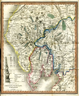
Map, hand coloured ?engraving, Map of the Lakes of
Cumberland, Westmorland, and Lancashire, scale about 4 miles
to 1 inch, published by Hudson and Nicholson, Kendal,
Westmorland, 1842.
Included at the back of A Complete Guide to the Lakes, which includes descriptions by William Wordsworth and letters on geology from Adam Sedgwick, published by Hudson and Nicholson, Kendal, and by Longman and Co and by Whittaker and Co, London, by Webb, Castle Street, Liverpoool, and by Simms and Co, Manchester, 1842. |
||

|
Hudson and Nicholson 1841 map | |
| map feature:- | folded (3x3) & piano key border & table of symbols & up is N & scale line & lat and long scales & sea plain & coast shaded & rivers & lakes & relief & hill hachuring & table of heights & forests & parks & county & settlements & roads & canals & railways | |
| inscription:- |
printed lower left
Map of the Lakes of / CUMBERLAND, WESTMORLAND, / & LANCASHIRE. |
|
| inscription:- |
printed bottom left, right
Published by Hudson & Nicholson, Kendal, for Wordsworths Guide to the Lakes, 1841. / Engraved by A. B. Johnson Birmingham. |
|
| inscription:- |
printed with scale line
Scale of Miles. |
|
| scale line:- | 10 miles = 61.3 mm | |
| wxh, sheet:- | 30.5x37.5cm | |
| wxh, map:- | 293x346mm | |
| scale:- | 1 to 260000 ? (1 to 262536 from scale line) | |