 Hudson and Nicholson 1841 map

|

|
|
|
map type:- Hudson and Nicholson 1841 map |
|
|
|
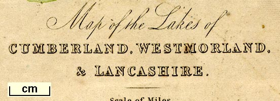
Map of the Lakes of Cumberland, Westmorland, and
Lancashire, scale about 4 miles to 1 inch, published by
Hudson and Nicholson, Kendal, Westmorland, and by Whittaker
and Co, Ave Maria Lane, London, 1841; perhaps published
about 1841-73.
Included at the back of A Handbook for Lake Visitors. Published in later editions of the guide book? |
||
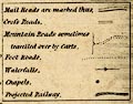
| map feature:- | mounted (linen?) & folded (3x2) & piano key border & table of symbols & up is N & scale line & lat and long scales & sea plain & coast shaded & rivers & lakes & relief & hill hachuring & table of heights & forests & parks & county & settlements & roads & canals & railways | |
| inscription:- |
printed lower left
Map of the Lakes of / CUMBERLAND, WESTMORLAND, / & LANCASHIRE. |
|
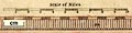
| inscription:- |
printed with scale line
Scale of Miles. |
|
| wxh, sheet:- | 29.5x34cm | |
| wxh, map:- | 292x338mm | |
| scale line:- | 10 miles = 62.1 mm | |
| scale:- | 1 to 260000 ? (1 to 259154 from scale line) | |
|
||
|
||
| sources:- |
Bicknell 1990 Armitt Library |
|
| items seen (illustrated items in bold):- | ||

|
Armitt Library : A1143.1 -- map -- Map of the Lakes of Cumberland, Westmorland, and Lancashire | |
|
|
Armitt Library : A1230.1 -- map -- Map of the Lakes of Cumberland, Westmorland, and Lancashire | |