 Rocque 1746

|

|
|
|
item:- Carlisle Library : Map 320 image:- © Carlisle Library |
click to enlarge |
|
|
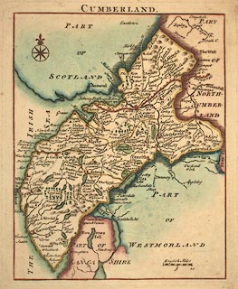
Map, hand coloured engraving, Cumberland, scale about 12
miles to 1 inch, by John Rocque, published Strand, London,
1753.
Published in The Small British Atlas: Being a new Set of Maps of all the Counties of England and Wales, about 1753. |
||

|
Rocque 1746 | |
| map feature:- | compass rose & up is N & scale line & sea plain & coast form lines & rivers & relief & hillocks & forests & parks & county & settlements & roads | |
| inscription:- |
printed top
CUMBERLAND. |
|
| inscription:- |
printed with scale line
English Miles |
|
| scale line:- | 10 miles = 20.8 mm | |
| scale:- | 1 to 770000 ? (1 to 772723 from scale line) | |
| wxh, sheet:- | 21x25cm | |
| wxh, plate:- | 168x203mm | |
| wxh, map:- | 153x192mm | |