 Hall 1833

|

|
|
|
item:- Carlisle Library : Map 199 image:- © Carlisle Library |
click to enlarge |
|
|
Map, hand coloured engraving, Westmoreland ie
Westmorland, scale about 5.5 miles to 1 inch, by Sidney
Hall, published by Chapman and Hall, 186 Strand, London,
1833, edition in 1860s or later.
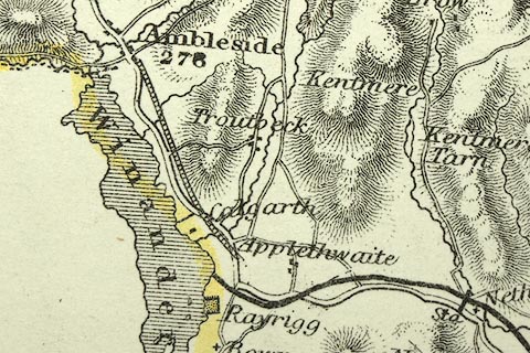
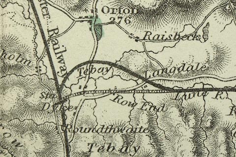
From A Travelling Atlas of the English Counties. Railways shown by a broad bold line are - Lancaster and Carlisle Railway, open 1846; Kendal and Windermere Railway, open 1846-47; Ulverstone and Lancaster Railway, open 1857; Low Gill and Ingleton branch railway, open 1861; South Durham and Lancashire Union Railway, open 1861; Railways shown by a double line with cross ties, light, are - Eden Valley Railway, open 1862; a line from Applethwaite ie Windermere to Ambleside, proposed at various dates; an alternative route of the South Durham and Lancashire Railway at Tebay. |
||

|
Hall 1833 | |
| map feature:- | plain cartouche & north point & scale line & lat and long scales & coast shaded & rivers & lakes & relief & hill hachuring & parks & county & wards (hundreds) & table of wards (hundreds) & settlements & roads & canals & railways | |
| inscription:- |
printed title cartouche, upper left, and under
WESTMORELAND. / ENGRAVED BY S. HALL. |
|
| inscription:- |
printed bottom
London. Published by Chapman & Hall No.186 Strand Mach 1833. |
|
| inscription:- |
printed with scale line
English Miles. |
|
| scale line:- | 10 miles = 49.4 mm | |
| scale:- | 1 to 330000 ? (1 to 325788 from scale line) | |
| wxh, sheet:- | 26.5x20.5cm | |
| wxh, map:- | 251x197mm | |
|
image:- © Carlisle Library |
|
|