 Cruchley 1858

|

|
|
|
item:- Kendal Library : Map 155 image:- © see bottom of page |
click to enlarge |
|
|
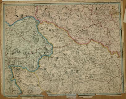
Map, colour lithograph, sheet 53 of a map of England and
Wales, scale about 2 miles to 1 inch, published by G F
Cruchley, 81 Fleet Street, London, 1858.
The map is from an atlas, Cruchley's Complete Railway and Station Map of England and Wales. Parts of Westmorland, Cumberland, Yorkshire East Riding, Yorkshire North Riding, Durham and Northumberland. Printed outside the map borders are links to adjacent sheets, eg 'Continuation West sheet 52.', north is 58, east is 54, south is 48. The railways partly shown are - Lancaster and Carlisle Railway, open 1846; Low Gill and Ingleton branch railway, open 1861; South Durham and Lancashire Union Railway, open 1861; Eden Valley Railway, open 1862. |
||

|
Cruchley 1858 | |
| map feature:- | up is N & scale line & lat and long scales & rivers & relief & hill hachuring & woods & forests & parks & county & settlements & roads & road distances & railways | |
| inscription:- |
printed bottom
[ ]E MAK[ER], 81 FLEET [S ] |
|
| inscription:- |
printed with scale line
Scale of Eng[lish Miles] |
|
| scale line:- | 20 miles = 251.9 mm | |
| wxh, sheet:- | 67x53cm | |
| wxh, map:- | 645x501mm | |
| scale:- | 1 to 130000 ? (1 to 127776 from scale line, assuming a statute mile) | |

|
||

|
||