 Cooke 1802

|

|
|
|
item:- Armitt Library : A1711.3 image:- © see bottom of page |
click to enlarge |
|
|
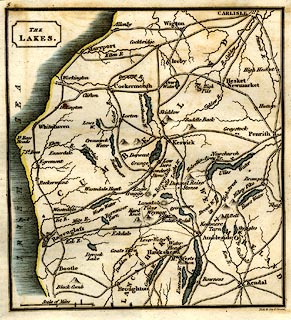
Map, The Lakes, Westmorland, Cumberland and Lancashire,
scale about 8.5 miles to 1 inch, by George Cooke, engraved
by Neele and Son, Strand, published by Sherwood, Jones and
Co, Paternoster Road, London, 1803-10.
Tiped in before p.1 of Excursions to the Lakes of Cumberland, by George Alexander Cooke. |
||

|
Cooke 1802 | |
| map feature:- | plain cartouche & up is N & scale line & sea plain & coast shaded & rivers & lakes & relief & hillocks & county & settlements & roads | |
| inscription:- |
printed upper left
THE LAKES |
|
| inscription:- |
printed bottom right
Neele & Son sc Strand |
|
| scale line:- | 10 miles = 30.6 mm | |
| wxh, sheet:- | 15x15cm | |
| wxh, map:- | 118x127mm | |
| scale:- | 1 to 530000 ? (1 to 525929 from scale line) | |