 Close 1805

|

|
|
|
item:- private collection (202_1) image:- © see bottom of page |
click to enlarge |
|
|
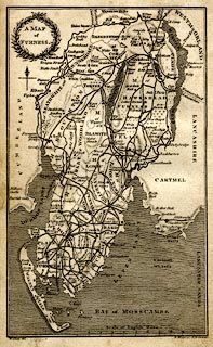
Map, uncoloured engraving, A Map of Furness, Lancashire,
scale about 4 miles to 1 inch, by William Close, engraved by
R Hixon, 355 Strand, London, published 1805.
Tipped in opposite p.1 in The Antiquities of Furness, by Thomas West, 2nd edn edited by William Close. |
||

|
Close 1805 | |
| map feature:- | floral cartouche & north point & up is N & scale line & sea shaded & coast line & rivers & lakes & relief & hill hachuring & parks & county & settlements & roads & canals | |
| inscription:- |
printed upper left, title cartouche
A MAP / of / FURNESS. |
|
| inscription:- |
printed bottom left, right
W. Close del. / R. Hixon sc. 355, Strand. |
|
| inscription:- |
printed with scale line
Scale of English Miles. |
|
| scale line:- | 10 miles = 61.6 mm | |
| wxh, sheet:- | 12.5x20.5cm | |
| wxh, map:- | 106x172mm | |
| scale:- | 1 to 270000 ? (1 to 267257 from scale line assuming statute miles) | |