 Map of Furness

|

|
|
|
map type:- Close 1805 |
|
|
|
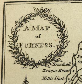
A Map of Furness, Lancashire, scale about 4 miles to 1
inch, drawn by William Close, engraved by R Hixon, Strand,
London, published by George Ashburner, Ulverston,
Lancashire, 1805.
Included in The Antiquities of Furness, by Thomas West. |
||
|
(example map Kendal Library (14_1))
|
||
| map feature:- | wreath cartouche & north point & up is N & scale line & sea shaded & coast line & rivers & lakes & relief & hill hachuring & woods & trees & county & manors & settlements & roads | |
| inscription:- |
printed title cartouche, upper left
A MAP / of / FURNESS. |
|
| inscription:- |
printed bottom left, right
W. Close del. / R Hixon Sc. 355 Strand. |
|
| wxh, sheet:- | 13x21cm | |
| wxh, 105x172mm:- | ||
| scale line:- | 10 miles = 61.6 mm | |
| scale:- | 1 to 260000 ? (1 to 261257 from scale line assuming a statute mile) | |
| sources:- |
Kendal Library Maps Carlisle Library Maps private collection |
|
| items seen (illustrated items in bold):- | ||

|
Carlisle Library : Map 71 -- map -- Map of Furness | |
|
|
Kendal Library (15_1) -- map -- Map of Furness | |
|
|
private collection (202_1) -- map -- Map of Furness | |