 Garwood 1913

|

|
|
|
item:- private collection (161_2) image:- © see bottom of page |
click to enlarge |
|
|
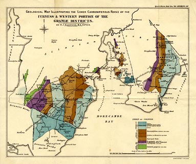
Geological Map, colour lithograph, Geological Map
Illustrating the Lower Carboniferous Rocks of the Furness
and Western Portion of the Grange Districts, scale about 1
inch to 1 mile, by E J Garwood, engraved by Weller and
Graham, published by the Geological Society of London, 1913.
Plate 55 in the Quarterly Journal of the Geological Society of London, vol.68. |
||

|
Garwood 1913 | |
| map feature:- | folded (4x2) & compass rose & up is N & scale line & sea plain & coast form lines & rivers & settlements & roads & geology & stratigraphical column | |
| inscription:- |
printed upper left
GEOLOGICAL MAP ILLUSTRATING THE / LOWER CARBONIFEROUS ROCKS OF THE / FURNESS & WESTERN PORTION OF THE / GRANGE DISTRICTS. / BY E. J. GARWOOD M.A., V.P.G.S. |
|
| inscription:- |
printed top right
Quart. Journ. Geol. Soc. Vol.LXVIII. Pl.LV. |
|
| inscription:- |
printed bottom right
Weller & Graham Ltd. Litho. London |
|
| inscription:- |
printed with scale line
Scale of One Inch to One Mile |
|
| scale line:- | 4+1 miles = 126.3 mm | |
| wxh, sheet:- | 44x36.5cm | |
| wxh, map:- | 375x306mm | |
| scale:- | 1 to 64000 ? (1 to 63711 from scale line) | |