 Cary 1809

|

|
|
|
item:- JandMN (317) image:- © see bottom of page |
click to enlarge |
|
|
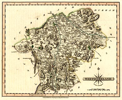
Map, hand coloured engraving, Westmoreland, scale about 5
miles to 1 inch, by John Cary, 181 Strand, London, 1809 or
later edition.
From the re-engraved edition of Cary's New and Correct English Atlas. (Note that the plate mark is a half inch outside the map border.) There is a page of descriptive text with the map. |
||

|
Cary 1809 | |
| map feature:- | compass rose cartouche & compass rose & up is N & scale line & lat and long scales & coast form lines & rivers & lakes & relief & hill hachuring & forests & parks & county & settlements & roads & canals | |
| inscription:- |
printed lower right in and below plain cartouche
WESTMORELAND / By JOHN CARY, Engraver. |
|
| inscription:- |
printed with scale line
Scale of Statute Miles 69 1/2 to a Degree |
|
| scale line:- | 10 miles = 50.1 mm | |
| wxh, sheet:- | 31.5x25.5cm | |
| wxh, plate:- | 289x240mm | |
| wxh, map:- | 264x213mm | |
| scale:- | 1 to 320000 ? (1 to 321226 from scale line assuming a statute mile) | |