 Johnson 1832

|

|
|
|
item:- private collection (261_1) image:- © see bottom of page |
click to enlarge |
|
|
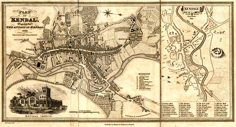
Map, uncoloured engraving, Plan of Kendal, scale about
7.5 miles to 1 inch, drawn by G H Johnson, engraved by
Franks and Johnson, Wakefield, Yorkshire, published by
Hudson and Nicholson, Kendal, Westmorland, 1832.
An inset map is Kendale, copy from John Speed, 1614. Tipped in opposite p.1 of The Annals of Kendal, by Cornelius Nicholson. The preface to the book acknowledges 'The Plan of the town is from a survey made by Mr. G. H. Johnson, whose talents as a draughtsman are quite sufficient to establish its accuracy.' |
||

|
Johnson 1832 | |
| inscription:- |
printed upper left
PLAN / OF / KENDAL, / Engraved for / THE ANNALS OF KENDAL, / 1832 / Engraved by Franks & Johnson, Wakefield. |
|
| inscription:- |
printed upper centre of inset map on right
KENDALE / From Speed's / Topography / 1614. |
|
| inscription:- |
printed bottom left, centre
G. H. Johnson Delt. / Published by Hudson & Nicholson, Kendal. |
|
| inscription:- |
printed with scale line
SCALE OF YARDS. |
|
| scale line:- | 400 yards = 42.3 mm | |
| map feature:- | mounted (linen) & folded (3, ie 2 folds) & greek key border & vignettes (Kendal Church) & compass rose & up is W & scale line & rivers & woods & settlements & streets & roads & canals & inset map | |
| wxh, sheet:- | 39.5x22cm | |
| wxh, map:- | 371x193mm | |
| scale:- | 1 to 8600 ? (1 to 8647 from scale line) | |