 Housman 1800 map 1

|

|
|
|
item:- JandMN (233_1) image:- © see bottom of page |
click to enlarge |
|
|
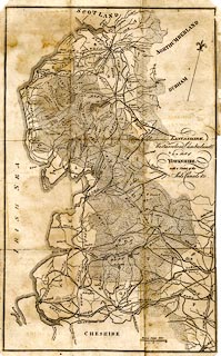
Map, uncoloured engraving, Lancashire, Westmoreland,
Cumberland and Part of Yorkshire, with a sketch of the Soils
Canals etc., scale about 8.5 miles to 1 inch, published by F
Jollie, Carlisle, Cumberland, 1800.
Taken from a guide book, A Descriptive Tour, and Guide to the Lakes, Caves, Mountains, ... by John Housman, 1800, 5th edn 1812. |
||

|
Housman 1800 map 1 | |
| map feature:- | table of symbols & north point & up is N (NNW) & scale line & sea plain & coast form lines & rivers & lakes & relief (a little) & hill hachuring & soils & county & settlements & roads & canals | |
| inscription:- |
printed middle right
LANCASHIRE, / Westmoreland, Cumberland, / & a Part of / YORKSHIRE. / with a Sketch of the / Soils Canals &c. |
|
| inscription:- |
printed page in the book, table of symbols
REFERENCES / TO THE / ANNEXED MAP OF THE SOILS, &c. / ... |
|
| inscription:- |
printed with scale line
British Statute Miles |
|
| wxh, sheet:- | 26.5x42.5cm | |
| wxh, map:- | 247x399mm | |
| scale:- | 1 to 530000 ? (1 to 531137 from scale line) | |
|
|
notes | |