 Housman 1800 map 1

|

|
|

|
back to object record | |
| Map Features | ||
|
The whole map covers more than just Cumbria; these notes are
strongly biased towards Cumbria interest and ignore some
features outside that area.
|
||
|
|
||
| title |
Printed middle right:-
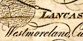
LANCASHIRE, Westmoreland, Cumberland, & a Part of YORKSHIRE. with a Sketch of the Soils Canals &c. The map is the frontispiece to the guide book. |
|
|
|
||
|
orientation
north point up is N |
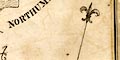
Printed upper left is a north point; N-S line, North marked by a fleur de lys. The map is printed with NNEby½N at the top of the sheet, the slight twist from North fits the long north south shape of the area onto the rectangular sheet. |
|
|
|
||
|
scale line
scale |
Printed lower off centre to the right is a scale of:-
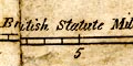
British Statute Miles marked in miles to 5 then at 10. The 10 miles = 30.3 mm gives a scale 1 to 531137. The map scale is about:- 1 to 530000 8.5 miles to 1 inch |
|
|
|
||
|
sea area
sea plain |
The sea area is plain, labelled:-
IRISH SEA with river estuaries labelled, and the:- Solway Firth |
|
|
|
||
|
coast line
coast form lines |
The coast line is emphasised by form lines. Headlands, harbours, etc, are not noticed. |
|
|
|
||
|
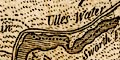
rivers
bridges |
Rivers are drawn by a wiggly line tapering upstream. Some
rivers are labelled in their estuaries, eg:-
River Dudden others by the streams, eg:- 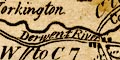
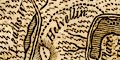
Derwent River and some sources are labelled, eg:- Eden-head From a casual look the rivers seem reasonably accurate, as should be expected on a map concerned with soils and cultivation not just topography. There are minor problems like the Lowther apparently ending south of Penrith, its course obscured by the road; and the headstreams of Grasmere lake and Thirlmere apparently join - but remembering how the Raise Beck behaves now, this is less surprising. Bridges are not particularly noticed, but may be implied where a road crosses and interrupts a stream. |
|
|
|
||
| lakes |
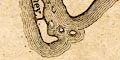
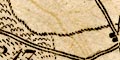
Lakes are drawn in outline and shaded. Some lakes are labelled:- Bassenthwaite W. Burnmoor Tarn Buttermere Coniston W Crumma Water Derwent Devock Lake Ennerdale W Grasmere Haws Water Leaths W [Thirlmere] Lows W. Ridal Ulles Water Wast Water Windermere Notice the five islands in Derwent Water shaped and arranged in a way suggestive of drumlins! Other lakes might be recognized, eg:- Brothers Water Easedale Tarn Esthwaite Water Kentmere Tarn lake, Cardurnock Over Water Skeggles Water Sunbiggin Tarn Talkin Tarn Tarn Wadling unidentified tarn near Talkin |
|
|
|
||
|
relief
hill hachuring |
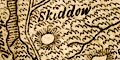
A few hills are shown by small rings of hill hachuring, in places there are groups of hachures but mostly the hills are isolated summits. Some hills are named, eg:- Skiddow Cross Fell Kidsty Pike There is no overall impression of hilly country, and the hills shown are not necessarily the most prominent. Scafell is missing. |
|
|
|
||
|
vegetation
geology |
Dotted lines are used to divide the region into areas, some of which have either pecking or a sort of underbrush symbol filling the area. These areas are labelled by letter, A to Q which refers to the table of symbols. This table describes each area in terms of vegetation, and comments on the economic geology, coal, limestone and metal ores. |
|
|
|
||
| table of symbols |
Printed on page in the guide book is a table of
symbols:-
REFERENCES TO THE ANNEXED MAP OF THE SOILS, &c. A ... Cold moist Loam is most prevalent. No Coal nor Limestone. B ... Mostly fertile clayey Loam, with Patches of Turnip Soil. No Coal nor Limestone. Level Surface. C ... Sand and light Loam in general, producing good Turnips. On the west side of Eden Clay predominates more frequently. D ... Soil generally strong; a Tract of Limestone about D. E ... Soil various; much light Gravel towards the Coast; on the other Side, a wet Soil, on a Clay Bottom, is most frequent. Coal and Limestone abound. F ... Soil mostly hazel Mould. No Coal. Limestone on the Banks of the Duddon. Some Freestone. G ... Generally a beautiful and romantic District, composed of several high rocky Mountains with pleasant intervening Dales, and many fine Lakes. The Soil mostly a dry Gravel. No Coal. A little Limestone about Ambleside. Blue Slate, Lead and Copper Ore, and Black Lead. H ... Heathy Mountains; Soil mossy. Coal, Limestone, Lead Ore. I ... Heathy Mountains, with mossy Tops, are generally prevalent; low Moors towards the North End. In the Southern parts are some fine woody Dales. The Soil of the inclosed Grounds more or less gravelly. K ... Verdant Hills, and pretty fertile Dales. Limestone in the greatest Abundance. Gravel and hazel Mould. L ... Dry gravelly Mould, and rich black Soil, with Tracts of Peat-moss. Several Coppice Woods. M ... The West Side flat and low; the East side rising a little. Soil loamy and pretty rich. Some Tracts of Peat-moss. N ... Surface flat, in general. Soil mostly a sandy Loam, on a sub-stratum of Clay or Marl. Peat-moss in several Places. Some Coal, and a little Limestone. O ... Surface and Soil somewhat like the last. Coal in abundance. P ... The Surface exhibits a few gentle Swells. Soil generally contains a greater or lesser mixture of Clay, with different degrees of Fertility. Coal, and excellent white Freestone. Q ... Hills, covered with Heath and coarse Herbage, prevail more or less though (sic) this District, with many fertile Vales. Some Coal and Limestone, particularly about the centre. |
|
|
|
||
| county |
Although counties are not labelled their boundaries are drawn by a dashed line which is usually continued alongside a boundary feature. This boundary should not be confused with the soil area boundaries. |
|
|
|
||
| settlements |
Settlements are marked by blocks, differentiated by style
of labelling.
|
|
|
cities
towns |
groups of blocks; labelled in upright lowercase text,
eg:-
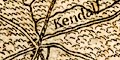
Kendal Carlisle Appleby Lists of towns see:- |
|
|
villages
hamlets |
group of blocks; labelled in italic lowercase text,
eg:-
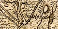
Ambleside Temple Sowerby |
|
|
|
||
|
roads
road distances |
A limited network of roads is drawn by double lines. The more important town to town distances are printed beside the routes, eg:- P to A 12 [Penrith to Appleby] K to P 26 [Kendal to Penrith] The roads with distances are a more limited network of presumably more important routes, but not quite the expected selection of routes, within Cumbria:- from Lancaster, Lancashire; then Kirkby Lonsdale, Kendal, Westmorland; to Penrith and Carlisle, Cumberland. from Penrith, Cumberland; through Appleby, Brough, to Kirkby Stephen, Westmorland. from Kendal, through Ambleside, Westmorland; then Keswick, Cockermouth, to Workington, Cumberland. from Bootle, through Ravenglass, Egremont, Whitehaven, Workington, Maryport, Allonby, Wigton, to Carlisle, Cumberland. from Cockermouth to Carlisle, Cumberland. from Penrith, through Hesket to Cockermouth, Cumberland. from Hesket to Carlisle, Cumberland. from Carlisle to Brampton, Cumberland. from Carlisle to Longtown, Cumberland. from Carlisle to Bowness-on-Solway, Cumberland. |
|
|
|
||
| canals |
Only one of the canals in the Cumbria area is shown, by a bold curved line:- |
|
| Lancaster Canal |
coming from West Houghton, through Preston and Lancaster,
Lancashire; to Kendal, Westmorland. Labelled:-
Lancaster Canal |
|
|
|
||
| miscellaneous | ||
|
|
||
|
antiquities
roman wall |
Drawn as a shaded line, running from Bowness-on-Solway,
past Carlisle, then eastward is the:-
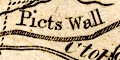
Picts Wall |
|
Lakes Guides menu.