 Collingwood 1899 map 2

|

|
|
|
item:- JandMN (190_2) image:- © see bottom of page |
click to enlarge |
|
|
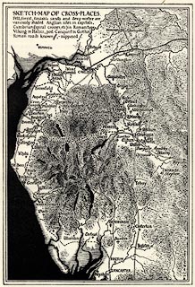
Map, uncoloured lithograph? Sketch Map of Cross Places,
scale roughly 13.5 miles to 1 inch, by W G Collingwood,
published for the Cumberland and Westmorland Antiquarian and
Archaeological Society, by Titus Wilson, Kendal,
Westmorland, 1899.
The maps shows the locations of anglian, viking, etc crosses, and known and supposed roman roads in Cumbria. Included as p.309 in Notes on the Early Sulptured Crosses, Shrines and Monuments in the Present Diocese of Carisle, by Rev William Slater Calverley, edited by W G Collingwood. |
||

|
Collingwood 1899 map 2 | |
| map feature:- | up is N & sea tinted & coast line & rivers & lakes & relief & settlements & roman roads | |
| inscription:- |
printed upper left
SKETCH-MAP OF CROSS-PLACES / ... |
|
| inscription:- |
printed lower right
W.G.C inv & delt. 1899 |
|
| wxh, sheet:- | 14x22cm | |
| wxh, map:- | 106x155mm | |
| scale:- | 1 to 850000 ? (estimate) | |