 Kitchin and Jefferys 1748

|

|
|
|
item:- Armitt Library : ALMC2008.14.30 image:- © see bottom of page |
click to enlarge |
|
|
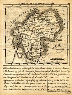
Map, uncoloured engraving, Westmoreland, scale about 12
miles to 1 inch, by Thomas Kitchin and Thomas Jefferys,
1748, published 1748-85.
Included in The Small English Atlas being a New and Accurate Sett Of Maps of all the Counties of England and Wales, published by Kitchin and Jefferys, London, 1751; during the life of this edition a plate number, 41, was added. There is descriptive text below the map is:- Westmoreland Contains 1 Borough & 6 other Market Towns & sends 4 Members to Parliament viz 2 for the County & 2 for the Borough of Appleby. Is bounded by Lancashire on the South & S.W. Cumberland on the W & N.W. and Yorkshire and the Bishoprick of Durham on the E. and N.E. / Appleby sends 2 Members Market S. Fairs Whit Mo. May 30 and June 10. / Kendal Market Sat. Fairs Mon. before Lady day & Trinity M. Mon. Apr. 25 and Oct. 28. / Kirkby Lonsdale Market Tues. / Kirkby Stephen Market F. Fairs Apr. 25 Oct. 18 & Whit Mon. / Ambleside Market Wed. / Brough Markt. Th. Fair Sep. 19. / Orton Markt. W. Fair Apr. 13. / Burton Markt. Tu. Fairs Mar. 25 & Whit Mond. |
||

|
Kitchin and Jefferys 1748 | |
| map feature:- | scale line & compass rose (basic) & up is N & lat and long scales & sea plain & coast form lines & rivers & lakes & relief & hillocks & woods & parks & county & settlements & roads & descriptive text | |
| inscription:- |
printed top
A Map of WESTMORELAND |
|
| inscription:- |
printed above scale line
English Miles |
|
| scale line:- | 10 miles = 22.9 mm | |
| longitude, Kendal:- | 2d 25m W | |
| wxh, sheet:- | 16x20cm | |
| wxh, map:- | 134x124mm | |
| scale:- | 1 to 700000 ? (1 to 702770 from scale line assuming a statute mile) | |
|
|
notes | |