 Kitchin and Jefferys 1748

|

|
|

|
back to object record | |
| MAP FEATURES | ||
|
|
||
|
title
map maker |
Printed at the top:-

A Map of WESTMORELAND Also notice the plate number, 41, which was added during the life of the plate. |
|
|
|
||
| descriptive text |
There is descriptive text below the map is:-
Westmoreland Contains 1 Borough & 6 other Market Towns & sends 4 Members to Parliament viz 2 for the County & 2 for the Borough of Appleby. Is bounded by Lancashire on the South & S.W. Cumberland on the W & N.W. and Yorkshire and the Bishoprick of Durham on the E. and N.E. / Appleby sends 2 Members Market S. Fairs Whit Mo. May 30 and June 10. / Kendal Market Sat. Fairs Mon. before Lady day & Trinity M. Mon. Apr. 25 and Oct. 28. / Kirkby Lonsdale Market Tues. / Kirkby Stephen Market F. Fairs Apr. 25 Oct. 18 & Whit Mon. / Ambleside Market Wed. / Brough Markt. Th. Fair Sep. 19. / Orton Markt. W. Fair Apr. 13. / Burton Markt. Tu. Fairs Mar. 25 & Whit Mond. |
|
|
|
||
|
orientation
compass rose up is N |
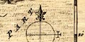
Printed lower right is a compass rose; circle, lines for cardinal directions, North marked by a fleur de lys spear point, East marked by a cross. The map is printed with North at the top of the sheet. |
|
|
|
||
|
scale
scale line |
Printed lower right is a scale of:-
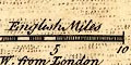
English Miles chequered in miles to 5 then in 5s. The 10 miles = 22.9 mm gives a map scale 1 to 702770 assuming a statute mile. The map scale is about:- 1 to 700000 12 miles to 1 inch |
|
|
|
||
| lat and long scales |
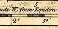
Printed in the map borders are scales of latitude and longitude for a rectangular projection; chequered in 5 minute intervals, labelled in 10s. The map includes from 1d 40m to 2d 55m W, from 53d 10m to 53d 50m N; the whole of Westmorland. From the longitude scales the longitude, Kendal = 2d 25m W Kendal is about 2d 49m W which suggests a prime meridian for the map 24m W of Greenwich, which is unlikely. |
|
|
|
||
|
sea area
sea plain |
Sea areas in the Kent and Leven Estuaries are plain.
|
|
|
|
||
|
coast line
coast form lines |
The coast line is emphasized by form lines. |
|
|
|
||
|
rivers
bridges |
Rivers are drawn by a wiggly line tapering upstream. The lower Kent and most of the Leven are drawn with a double line. Some rivers are labelled, eg:- Can or Kent R. R. Burrow Eden R. Bridges are implied where a road crosses and, probably, interrupts a stream, but are also marked by a double line across a stream with no road attached. 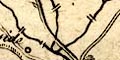
Few are labelled, notice:- Burrow Bridge ie Low Borrow Bridge south of Tebay. |
|
|
|
||
| lakes |
Lakes are drawn by an outline with form lines, the middle of the lake pecked. Some lakes are labelled:- Winander Meer Other lakes or tarns might be recognized, eg:- Blelham Tarn Brothers Water Coniston Water Easedale Tarn Grasmere lake + Rydal Water Hawes Water Hayeswater Thirlmere Ullswater |
|
|
|
||
|
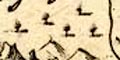
relief
hillocks |
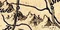
Some relief is indicated by small but craggy hillocks. They do not provide a realistic depiction of the shape of the county. There are groups of hills east of Langdale, on the county border at Milburn, along Mallerstang, and a small mountainous chain from Tebay towards Hawes Water. Over the county boundary the Pennines run down the east and there is a large range of hills north of Penrith. The emphaseses do not all match reality. Hills are mostly unlabelled, but notice:- Belcome Hill on the road north from Kendal. |
|
|
|
||
|
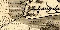
woods
trees forests |
A thin scatter of tree symbols suggests woodland or 'forest' at Mallerstang. A forest area might be labelled, eg:- Milburn For: |
|
|
|
||
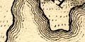
| parks |
Parks are drawn by a ring of fence palings, none labelled, though many can be recognized. |
|
|
|
||
| county |
The county boundary is a bold dashed line, carried on alongside a boundary feature, emphasized by heavy shading into the adjacent county area, Westmorland thrown into prominence by this and the dotting of the surrounding areas. Boundaries between adjacent counties are a light dotted line. Note that Windermere lake and part of Ullswater are correctly included in the county. Adjacent counties are labelled, eg:- P. OF CUMBERLAND PART OF YORK SH: some map features outwith the county are shown for the sake of continuity. Descriptive text supplies information about the county. |
|
|
|
||
| settlements |
Settlements are marked by a circle with added elements,
further differentiated by style of labelling.
|
|
|
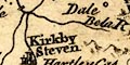
towns
electoral data distances from London |
circle, buildings and tower; labelled in upright
lowercase text, eg:-
Kirkby Steven Kendal 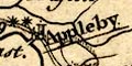
Appleby / 279 |
|
|
Appleby is underlined, being the de jure county town; it
has two stars attached for the two members it sends to
Parliament; and is labelled with its distance from
London.
KJ01Twn.txt |
||
|
villages
hamlets |
circle; labelled in italic lowercase text, eg:-
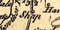
Shap Kentmere Hardendale |
|
|
castles
houses |
circle; labelled in italic lowercase text, eg:-
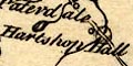
Hartsop Hall Pendragon Cas. Wharton H. Kirby Thore & Whelp C. |
|
|
|
||
|
roads
road distances |
Roads are drawn by solid double lines.*COMMENT3 A few road distances are marked between towns, for example 25 1/2 between Kendal and Penrith. The marking of distances suggest that the route from the south through Kendal to Penrith, and rom Kendal through Ambleside towards Keswick, are more important routes. On another map, Bowen and Kitchin 1760, these are declared as the post roads. The Lancaster Penrith road is also engraved with light bold lines, another way post roads are marked on some maps. |
|
|
|
||
| miscellaneous | ||
|
|
||
|
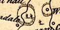
antiquities
earthworks |
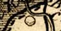
Although not labelled, a ring engraved SW of the road crossing the Eamont could be meant for King Arthur's Round Table. |
|
Lakes Guides menu.