 Kitchin and Jefferys 1748

|

|
|
|
map type:- Kitchin and Jefferys 1748 |
|
|
|
Map of Westmoreland, scale about 9 miles to 1 inch, and
Cumberland? by Thomas Kitchin and Thomas Jefferys, 1748,
published 1748-85.
Published in 'The Small English Atlas being a New and Accurate Sett Of Maps of all the Counties of England and Wales London, Publish'd according to Act of Parliamt. by Messrs. Kitchin & Jefferys 1749. and Sold by M Payne at the White Hart and M. Cooper at the Globe in Paternoster Row.' The atlas size is 5 1/2 x 6 3/8 ins; the map has notes of fairs, market days, Members of Parliament, etc on the sheet outside the border, plain on the reverse; it is based on Morden 1695? The atlas was first published in weekly parts; Westmoreland appeared in part 1 advertised in the London Evening Post, 17-19 November 1748:- 'This Day is publish'd, Price 6d. Neatly engrav'd and colour'd, (Being the cheapest and correctest Work of the Kind) Number I. of The Small English Atlas: Being a new and accurate Sett of Maps of all the Counties of England and Wales: Design'd and engrav'd in a portable Size for the Use of Travellers. ...' There is no plate number; the map was printed on a sheet with other maps. Published in another edition '... London Publish'd according to Act of Parliamt. by Messrs Kitchin & Jefferys 1751, and sold by Thos. Jefferys Geographer to his Royal Highness the Prince of Wales at the corner of St. Martins Lane, Charing Cross, by Mr George Faulkner in Essex Street, Dublin. A Paris chez le Sr. le Rouge Ingenieur Geographe du Roy de France.' The map is mostly unchanged, but during the life of this edition a plate number, 41, was added. Published in 'The Small English Atlas ... By T Jefferys, Geor. to the King, and Thos. Kitchin Senr. London: Printed for Robert Sayer and John Bennett, No.53 Fleet Street, John Bowles, No.13 in Cornhill, and Carington Bowles, No.69 in St. Pauls Church Yard.' about 1775. The plate for the map is now cut up from its companions; there are additions to roads, eg Appleby through Kirkby Stephen; and the canal south of Kendal is shown; hundred, ie ward, boundaries are added; descriptive text is revised. Published in 'An English Atlas Or A Concise View Of England And Wales; Divided into Counties, and its Subdivisions into Hundreds &c. Describing Their Situation, Extent, Boundaries, Circumference, Soil, Product, Chief Rivers and the Principal Great and Bye-Roads; with a Chart of the Distances between the Cities and Chief Towns. Together with A Description of the Situation of the most Venerable Antiquities whether Ruins of Castles, Palaces, or Monasteries, as well as the most Remarkable Houses, Plantations, &c. Pointing out every Delightful Scene of extensive Prospect, and Curiosities of Art and Nature worthy a Travellers Notice. On Fifty Two Copper Plates. Published as the Act directs 1 Augt. 1776. London. Printed for Robt. Sayer, and Jno. Bennett, Map and Printsellers, No.53, in Fleet Street.' Published in 'An English Atlas Or A Concise View of England and Wales; ... Published as the Act directs. 1 Augt. 1787. London. Printed for Robt. Sayer, No.53, in Fleet Street.' Published in further editions, by Sayer's successors, Robert Laurie and James Whittle, about 1794 and 1796. |
||
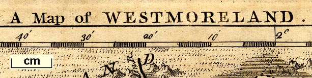
| scale line:- | 10 miles = 28 mm | |
| scale:- | 1 to 550000 ? (1 to 547766 from scale line assuming a statute mile) | |
| map feature:- | scale line & compass rose (basic) & up is N & lat and long scales & sea plain & coast form lines & rivers & lakes & relief & hillocks & woods & parks & county & settlements & roads & descriptive text | |
| inscription:- |
printed top
A Map of WESTMORELAND |
|
| wxh, sheet:- | 16x20cm | |
| wxh, map:- | 134x124mm | |
| inscription:- |
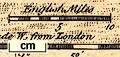
printed above scale line
English Miles |
|
| scale line:- | 10 miles = 22.9 mm | |
| scale:- | 1 to 700000 ? (1 to 702770 from scale line assuming a statute mile) | |
| longitude, Kendal:- | 2d 25m W | |
|
||
| references:- |
Kitchin, Thomas & Jefferys, Thomas: 1749: Small English
Atlas: Payne, M & Cooper, M (London) Kitchin, Thomas & Jefferys, Thomas: 1751: Small English Atlas: (London) Kitchin, Thomas & Jefferys, Thomas: 1775: Small English Atlas: Sayer, Robert & Bennett, John & Bowles, John & Bowles, Carington (London) Kitchin, Thomas & Jefferys, Thomas: 1776: Small English Atlas & Concise View of England and Wales: Sayer, Robert & Bennett, John (London) : 1794 & 1796: English Atlas & Concise View of England and Wales: Laurie, Robert & Whittle, James (London) |
|
| sources:- |
Chubb 1927 (CXCII) Hodson 1984 Armitt Library Kendal Library Maps |
|
| items seen (illustrated items in bold):- | ||

|
Armitt Library : ALMC2008.14.30 -- map -- Map of Westmoreland | |
|
|
Kendal Library : Map 44 -- map -- Map of Westmoreland | |