 Hollar 1644

|

|
|
|
item:- private collection (120) image:- © see bottom of page |
click to enlarge |
|
|
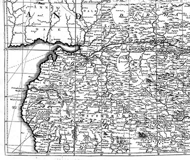
Map, bw photocopy, Cumberland Northumberland Westmorland
Bishoprick of Durham, scale roughly 6 miles to 1 inch, by
Wenceslaus Hollar, published by Thomas Jenner London, 1644,
an edition after 1675.
This is one sheet of the Quartermaster Map of the Kingdome of England and Principality of Wales. |
||

|
Hollar 1644 | |
| map feature:- | up is N & rhumb lines (?) & lat and long scales & lat and long grid & sea plain & coast shaded & rivers & lakes & relief & hillocks & forests & county & diocese & settlements & roads | |
| inscription:- |
printed top
CUMBERLAND NORTHUMBERLD WESTMORLD BPPK OF DURHAM |
|
| longitude, Kendal:- | 2d 44m W | |
| scale:- | 1 to 400000 ? (rough estimate) | |
|
|
notes | |