 Bishop-ricke of Durram and Cumberland, Westmoreland,
...
Bishop-ricke of Durram and Cumberland, Westmoreland,
...

|

|
|
|
map type:- Hollar 1644 |
|
|
|
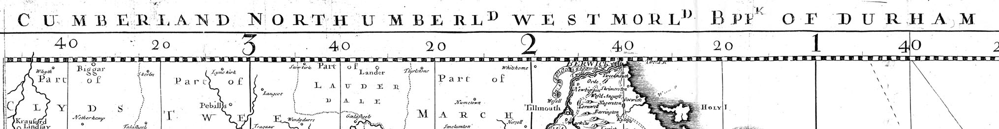
Map, Bishop-ricke of Durram and Cumberland, Westmoreland,
Yorke-shire, Lancast-shire, and parte of Lincolnshire, scale
about 5.5 miles to 1 inch, by Wenceslaus Hollar, published
by Thomas Jenner, London, 1644; published 1644-1759.
Based on the large wall map of England and Wales, 'Britannia Insularum in Oceano Maximo' by Christopher Saxton, 1583. The maps are known as the Quartermaster's Maps; compiled by order of Oliver Cromwell. Published in a set of six folded maps of 'The Kingdom of England and Principality of Wales exactly described, with every sheere, and the small townes in every one of them, in six mappes, portable for every man's pocket; useful for all commanders and quarteringe of souldiers and all sorts of person that would be informed where the Armies be, never so Commodiously drawne before this. ...' 1644. Published again by Thomas Jenner, '... useful for all gentlemen and travaillers that would be informed of the distance of places. Described by one that travailed throughout the whole Kingdome for its purpose. Sold by Thomas Jenner, at the South Entrance of ye Exchange. W. Hollar fecit.' 1671. Published with roads added, 'Printed and sold by J. Garrett, at the South Entrance of ye Exchange. W. Hollar fecit.' 1675; and on silk, 1676 and 1688. The maps have main roads drawn by a double line, and minor roads by a single line. Published by John Rocque, London, 1752 and 1759. |
||
|
(map example, not seen)
|
||
| map feature:- | title cartouche & compass rose & scale line & rivers & lakes & relief & woods & county & settlements & roads | |
| inscription:- |
printed title cartouche
[THE BISHOP-RICKE OF DURRAM AND CUMBERLAND, WESTMORELAND, YORKE-SHIRE, LANCAST-SHIRE, AND PARTE OF LINCOLNSHIRE.] |
|
| scale line:- | 20 miles = 3.5 ins | |
| scale:- | 1 to 360000 ? | |
| wxh, sheet:- | 53x41cm (approx) | |
| sources:- |
Curwen 1918 David Webb Collection |
|
| items seen (illustrated items in bold):- | ||

|
private collection (120) -- map -- Cumberland Northumberland Westmorland Bishoprick of Durham -- Quartermaster Map -- Kingdome of England and Principality of Wales | |