 Hollar 1644

|

|
|

|
back to object record | |
| MAP FEATURES | ||
|
These notes are made from a photocopy. The notes are
strongly biased toward interest in Westmorland, Cumberland,
etc, features in other parts might be ignored.
|
||
|
|
||
| title |
Printed at the top:-
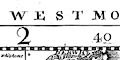
CUMBERLAND NORTHUMBERLD WESTMORLD BPPK OF DURHAM |
|
|
|
||
|
orientation
up is N |
The map is printed with North at the top of the
sheet.
|
|
|
|
||
| scale |
The scale was estimated from the distance from Carlisle
to Kendal. The map scale is roughly
1 to 400000 ? 6 miles to 1 inch |
|
|
|
||
|
lat and long scales
lat and long grid |
Printed in the map borders are scale of latitude and longitude for a ?conical projection; marked in minutes, labelled at 10s. The top longitude scale is chequered in minutes. The map includes from 0d 15m to 3d 50m W, from 54d 18m to 55d 48m N; all of Cumberland, most of Westmorland, part of Lancashire north of the sands, Northumberland, Durham, part of Yorkshire. From the scales the longitude, Kendal = 2d 44m W which suggests a prime meridian close to Greenwich (but not to be assumed). A graticule is drawn across the map at 10 minute intervals. |
|
|
|
||
|
sea area
sea plain rhumb lines |
The sea area is plain. There are lines at odd angles
across the sea areas which look like rhumb lines from
centres off this sheet of the map. I have not tried to
produce lines back to possible centres to make further
deductions.
|
|
|
|
||
|
coast line
coast shaded headlands harbours |
The coast line is emphasized by two densities of shading. A few headlands are noticed, eg:- S. Bees Head Few harbours are noticed, but see:- Derwentfoot Haven labelled by Workington. And off Tinmouth is:- Tinmouth bar and Road |
|
|
|
||
|
rivers
bridges |
Rivers are drawn by a wiggly line. Larger rivers might
end as a double line with shading or stream lines, higher up
the line is single. some rivers are named, eg:-
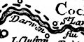
Darwen flu Can flu Eimo flu 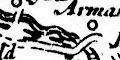
Bridges are implied where a road crosses and interrupts a stream, but also by a double line crossing a stream where no road is shown. None? are labelled in Cumberland, Westmorland, but notice:- Corbridg labelling a bridge symbol not a settlement. |
|
|
|
||
| lakes |
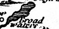
Lakes are drawn in outline, shaded. Some lakes are labelled (Cumbria only):- Broad Water [Ennerdale Water] Thurlmyre flu Wynander mere Notice that either Thirlmere is regarded as a river, or the other meaning of flud is being used, a flood, a lake. Other lakes might be recognized (Cumbria only), eg:- Bassenthwaite Lake Bleaberry Tarn (? bigger than Buttermere, but plotted in the position of the small tarn) Buttermere Coniston Water Derwent Water Devoke Water Loweswater Ullswater [not shaded] Wast Water [non existent tarn, in Eskdale] |
|
|
|
||
|
relief
hillocks |
Relief is indicated by small rugged hillocks shaded to the east. They are not particularly organised, but there are groups in the central Lake District, the Pennines, scottish borders, etc. A few are labelled, eg:- 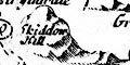
Skiddow Hill Kelloplaw hill A couple of hillocks are larger, for example (in and around Cumbria): Skiddaw; what could be meant to be Sca Fell; perhaps Whinfell north of Lambrigg; Kelloplaw Hill north of Alston; and Huseatmorvell hill by Mallerstang. |
|
|
|
||
|
forests
trees |
Woodland is not much indicated. A large group of tress is
labelled:-
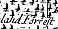
Copland Forrest / Copeland Forrest Other forests, without tree symbols though they might have had more, are also labelled, eg:- Westward Forrest Inglewood Forrest |
|
|
|
||
|
county
diocese |
As far as I can judge from this one sheet of six, the
county boundaries are a dotted line, diocesan boundaries are
a dashed line, and where the two run together a dot dot dash
line is used. This needs to be checked on the whole set of
maps, or perhaps in an introduction to the set of maps? At
the period of the map most of Cumberland and half of
Westmorland was in the Diocese of Carlisle; two small areas
of Cumberland were in the Diocese of Durham; a south part of
Cumberland, the south half of Westmorland, Lancashire north
of the sands, and the area around Sedbergh, were in the
Diocese of Chester. What is shown on the map does not match
the dioceses of the period exactly: the map maker might have
confused county and diocese in some places. Boundaries are
continued alongside a feature which is the boundary.
Examples of the three type of boundary line can be seen at the Three Shire Stones. 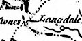
County areas are labelled, eg:- WESTMORLAND and diocesan areas are labelled, eg:- DIOCESE OF CARLISLE |
|
|
|
||
| settlements |
Settlements are mostly marked by a circle, perhaps with
added elements, further differentiated by style of
labelling.
|
|
|
cities
street map |
group of blocks on a miniature street plan; labelled in
upright block caps:-
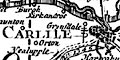
CARLILE There are additional symbols alongside; a double cross and a ?letter P. Lacking a table of symbols I don't know what these mean. |
|
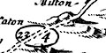
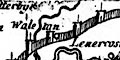
| towns |
bold circle, one, two or three towers; labelled in
upright lowercase text, eg:-
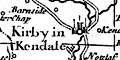
Kirby in Kendale Keswick Apalby Appleby and Cockermouth have two towers and a letter P; Kendal has three towers; Ambleside on towers; Shap one tower and a building; Keswick one tower; and so on. |
|
|
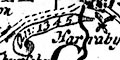
villages
hamlets |
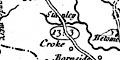
usually a circle, sometimes missing; labelled in italic lowercase text, eg:- Barton Langstedale Anstable Croke A block or two might be used instead, as at:- Stanley [Staveley] Knowing that the roads were added, and this place is significant on the road, perhaps the blocks and label were added as well? |
|
|
|
||
|
roads
road distances |
A few roads are drawn by double line, solid or dotted for fenced or unfenced, or at least for less wild and wilder parts of the route. The maps was first published 1644 without roads; road were added in editions from 1675. In places the road is broken so as not to interfere with placename labels, as at Cliffe Chapell south of Penrith. Elsewhere the road, place marking and label, are a neat whole, as at Staveley. Perhaps places were added as well as roads. The roads shown (in Cumbria) are the routes included by John Ogilby in his road book published 1675. Road distances are given in miles and furlongs in an oval cartouche on the road, between towns. from the south through Kirby in Kendale, 13'3 to Shap, Westmorland; 10'2 to Penrith, 18'2 to Carlile, Cumberland. from Kirby in Kendale, 13'3 to Ambleside, Westmorland; 16'2 to Keswick, 14'0 to Cockermouth, Cumberland. from Egremont, 14[ ] to Cockermouth, 9[ ] to Ireby, 16'3 to Carlile, Cumberland. from the east through Haltwhistle, Northumberland; 23'4, passing round Brampton, to Carlile, Cumberland. from Carlile, through Longtown, Cumberland; into Scotland. |
|
|
|
||
| miscellaneous | ||
|
|
||
| stones |
At the meet of county boundaries is labelled:-
Shire Stones |
|
|
|
||
|
antiquities
roman wall |
Hadrian's Wall is drawn by an impressive wall with towers at close intervals, labelled:- The Picts Wall |
|
|
|
||
| battles |
?Battles are marked by crossed swords, scimitars, with a
label in a scroll cartouche. For example, at the south side
of Carlisle:-
an: 1345 And at Egremont:- [a: 1071] |
|
Lakes Guides menu.