 Dawson 1830s

|

|
|
|
item:- Carlisle Library : Map 112 image:- © Carlisle Library |
click to enlarge |
|
|
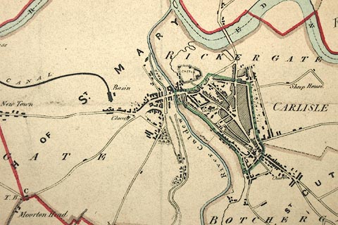
Map, hand coloured lithograph, Carlisle, proposed new
boundary, scale about 3 inches to 1 mile, by Captain Robert
K Dawson, lithographed by Josiah Nethercliff, 54 Leicester
Square, London, about 1832.
Surveyed by R Thornton and T Smith. Drawn for the Reform Act 1832. The table of symbols has - 'Explanations / Boundary of Old Borough ... Green / Proposed Boundary ... Red / Boundaries of Parishes and Townships ... Brown Rivers ... Blue' |
||

|
Dawson 1830s | |
| map feature:- | table of symbols & north point & up is N & scale line & rivers & woods & settlements & roads & canals ('SOLWAY CANAL') & electoral data | |
| inscription:- |
printed upper off centre
CARLISLE. |
|
| inscription:- |
printed lower left
Robt. K. Dawson Lieut. R.E. / R. Thornton & T. Smith Surveyors |
|
| inscription:- |
printed bottom
Josh. Nethercliff Lithog. 54, Leicester Sq. |
|
| inscription:- |
printed with scale line
Scale, 3 inches to a Mile |
|
| scale line:- | 1+1 miles = 152.5 mm | |
| wxh, sheet:- | 38x33cm | |
| wxh, map:- | 36x35cm | |
| scale:- | 1 to 21000 ? (1 to 21106 from scale line, assuming a statute mile) | |