 Hydrographic Office 1850s onwards

|

|
|
|
item:- Carlisle Library : Map 94 image:- © Carlisle Library |
click to enlarge | |
| Illustration of part of map only. | ||
|
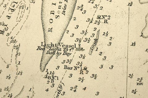
Chart, uncoloured engraving, England West Coast sheet
XII, Firth of Solway, scale about 1 inch to 1 mile, surveyed
by C G Robinson, 1837, engraved by J and C Walker, published
by the Hydrographic Office, The Admiralty, London, 1841-58.
An inset map shows the River Nith up to Dumfries. |
||

|
Hydrographic Office 1850s onwards | |
| map feature:- | table of symbols & compass rose & magnetic deviation (24d 25m W) & up is N & lat and long scales & sea plain & depth soundings & depth contours & sandbanks & tidal streams & buoys & anchorages & coast shaded (inland side) & harbours & headlands & foreshore sands & coast views & lighthouses & leading lines & rivers & relief & hill hachuring & county & settlements & roads (few) & railways & inset map | |
| inscription:- |
printed middle right
... / ENGLAND / WEST COAST / SHEET XII / THE / FIRTH OF SOLWAY / SURVEYED BY COMMR. C. G. ROBINSON R.N. F.G.S. / 1837 / Corrections to 1857 / ... / Natural Scale 1/73,000 / ... |
|
| inscription:- |
printed bottom
London Published according to Act of Parliament at the Hydrographic Office of the Admiralty May 13th. 1841. Corrected to June 1844 and Augt. 1856 - 1857 - March 1858. / Sold by J. D. Potter Agent for the Sale of the Admiralty Charts 31 Poultry & 11 King St. Tower Hill. |
|
| inscription:- |
printed bottom right
J. & C. Walker. Sculpt. |
|
| wxh, sheet:- | 95.5x67cm | |
| wxh, map:- | 925x625mm | |
| scale:- | 1 to 73000 ? (nominal) | |
|
image:- © Carlisle Library |
|
|