 Backhouse 1773

|

|
|
|
item:- private collection (224) image:- © see bottom of page |
click to enlarge |
|
|
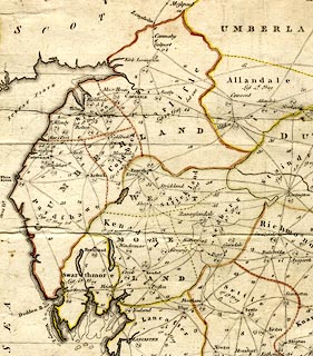
Map, hand coloured engraving, Map of the Meetings
belonging to the Quarterly Meetings of Lancaster,
Westmorland, Cumberland, Northumberland, Durham and York,
scale about 9 miles to 1 inch, by James Backhouse, engraved
by Thomas Kitchin, published by James Backhouse, Darlington,
Durham, 1773.
The map has an 'Explanation' of the monthly, quarterly, and yearly meetings, etc. |
||

|
Backhouse 1773 | |
| map feature:- | mounted (linen) & folded (3x2) & floral cartouche & compass rose & up is N & lat and long scales & lat and long grid & sea plain & coast form lines & lakes & county & settlements & roads & road distances & market days | |
| inscription:- |
printed
A MAP / of the MEETINGS, / belonging to the / QUARTERLY MEETINGS / of LANCASTER, / WESTMORELAND, / CUMBERLAND, / NORTHUMBERLAND, / DURHAM & / YORK. / By James Backhouse, / 1773 // Engraved by Thos. Kitchin. |
|
| inscription:- |
printed bottom
Publish'd as the Act Directs 1st. 3d. Moth. 1773, by the Author at DARLINGTON, Price 1s. 6d., also sold by T. Kitchin, No.59, Holborn Hill, London. |
|
| longitude, Kendal:- | 2d 51d W | |
| wxh, sheet:- | 49x54cm | |
| wxh, map:- | 482x525mm | |
| scale:- | 1 to 580000 ? (estimate) | |
|
||
|
|
notes | |