 Marr 1916 map

|

|
|
|
item:- JandMN (173_5) image:- © see bottom of page |
click to enlarge |
|
|
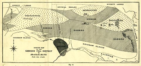
Geological map, uncoloured lithograph, Sketch Map of the
Carrock Fell District, scale about 3 inches to 1 mile, by
Alfred Harker, published by Cambridge University Press,
Cambridge, Cambridgeshire, 1916.
Folded and tipped in opposite p.105 in The Geology of the Lake District by J E Marr. |
||

|
Marr 1916 map | |
| map feature:- | compass rose & up is N & rivers & geology | |
| inscription:- |
printed lower left
SKETCH MAP / OF THE / CARROCK FELL DISTRICT / by / Alfred Harker, M.A. F.G.S. |
|
| wxh, sheet:- | 32.5x22cm | |
| wxh, map:- | 279x126mm | |