 Thomas 1916

|

|
|
|
item:- JandMN (173_1) image:- © see bottom of page |
click to enlarge |
|
|
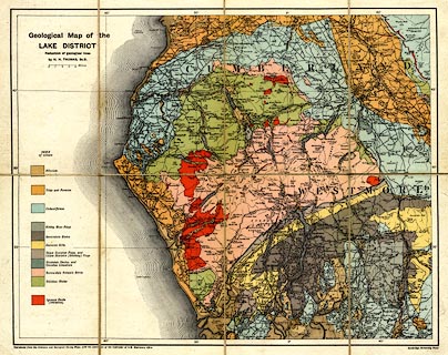
Geological map, colour printed, Geological Map of the
Lake District, scale about 4 miles to 1 inch, by H N Thomas
based on the Ordnance and Geological Survey maps, published
by Cambridge University Press, Cambridge, Cambridgeshire,
1916.
Folded and inserted in a pocket at the end of The Geology of the Lake District by J E Marr. |
||

|
Thomas 1916 | |
| map feature:- | sectioned for folding & mounted (on linen) & folded (4x2) & up is N & scale line & lat and long scales & lat and long grid & sea plain & coast form lines & rivers & lakes & relief & spot heights & woods & forests & woods & parks & county & settlements & roads & railways & canals & geology & stratigraphical column | |
| inscription:- |
printed upper left
Geological Map of the / LAKE DISTRICT / Reduction of Geological Lines |
|
| inscription:- |
printed bottom left, right
Reproduced from the Ordnance and Geological Survey Maps, with the sanction of the Controller of H.M. Stationery Office / Cambridge University Press |
|
| inscription:- |
printed with scale line
Miles |
|
| scale line:- | 4 miles = 25.1 mm | |
| wxh, sheet:- | 46.5x39cm | |
| wxh, map:- | 398x313mm | |
| scale:- | 1 to 260000 ? (1 to 256469 from scale line) | |
|
|
notes | |