 Whittaker 1821

|

|
|
|
item:- Armitt Library : ALMC2008.14.124.1 image:- © see bottom of page |
click to enlarge |
|
|
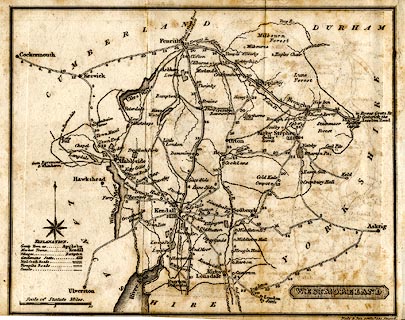
Map, uncoloured engraving, Westmoreland ie Westmorland,
scale about 8.5 miles to 1 inch, engraved by Neele and Son,
352 Strand, published by G and W B Whittaker, Ave Maria
Lane, London, 1822.
Frontispiece zigzag folded into The History and Topography of Westmoreland, in Pinnock's County History series. |
||

|
Whittaker 1821 | |
| map feature:- | plain cartouche & table of symbols & compass rose & up is N & scale line & coast form lines & rivers & lakes & parks & county & settlements & roads & road distances & post roads & turnpike roads | |
| inscription:- |
printed title cartouche, lower right
WESTMORELAND |
|
| inscription:- |
printed above scale line
Scale of Statute Miles. |
|
| scale line:- | 10 miles = 29.4 mm | |
| scale:- | 1 to 550000 ? (1 to 547396 from scale line) | |
| wxh, sheet:- | 18x13.5cm | |
| wxh, map:- | 161x129mm | |