 Wallis 1812

|

|
|
|
item:- Armitt Library : ALMC2008.14.110 image:- © see bottom of page |
click to enlarge |
|
|
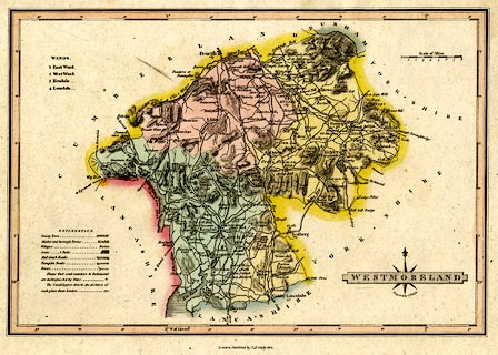
Map, hand coloured engraving, Westmoreland ie
Westmorland, scale about 6 miles to 1 inch, by James Wallis,
London, published by S A Oddy, London, 1812.
Included in A New and Improved County Atlas, 1812. |
||

|
Wallis 1812 | |
| map feature:- | compass rose cartouche & table of symbols & compass rose & up is N & scale line & lat and long scales (rectangular projection? W of Greenwich) & coast shaded & rivers & lakes & relief & hill hachuring & parks & county & wards & table of wards & settlements & roads & distances from London & canals | |
| inscription:- |
printed title cartouche, lower right
WESTMORELAND / Engrav'd by J. Wallis. |
|
| inscription:- |
printed bottom
London, Publish'd by S. A. Oddy, 1812. |
|
| inscription:- |
printed above scale line
Scale of Miles |
|
| scale line:- | 8 miles = 33.2 mm | |
| scale:- | 1 to 390000 ? (1 to 387794 from scale line) | |
| wxh, sheet:- | 30x22.5cm | |
| wxh, map:- | 265x183mm | |