 Collins 1849-52

|

|
|
|
item:- Armitt Library : ALMC2008.14.108 image:- © see bottom of page |
click to enlarge |
|
|
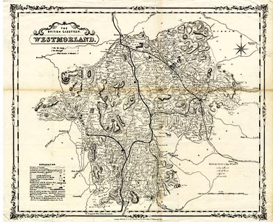
Map, uncoloured lithograph, Westmorland, scale about 3
miles to 1 inch, published by Henry G Collins, 22
Paternoster Row, London, 1849-52.
Included in The British Gazetteer by Benjamin Clarke. The railways are boldly overprinted on an existing map. |
||

|
Collins 1849-52 | |
| map feature:- | decorative border & table of symbols & plain cartouche & compass rose & up is N & scale line & lat and long scales (rectangular projection; W from Greenwich) & sea plain & coast line & rivers & lakes & relief & hill hachuring & woods & forests & parks & county & wards & table of wards & electoral data & settlements & roads & turnpike roads & post roads & road distances & distances from London & railways | |
| inscription:- |
printed title cartouche, upper left
THE / BRITISH GAZETTEER. / WESTMORLAND. |
|
| inscription:- |
printed bottom
London Published for the proprietors by H. G. Collins 22 Paternoster Row. |
|
| inscription:- |
printed with scale line
Scale. / Miles. |
|
| scale line:- | 8+1 miles = 75.3 mm | |
| wxh, sheet:- | 45x37cm | |
| wxh, map:- | 42.5x35.5cm | |
| scale:- | 1 to 190000 ? (1 to 192352 from scale line assuming a statute mile) | |