 Perrot 1823

|

|
|
|
item:- Armitt Library : ALMC2008.14.76 image:- © see bottom of page |
click to enlarge |
|
|
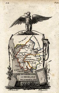
Map, hand coloured engraving, Cumberland and Westmoreland
ie Westmorland, scale about 38 miles to 1 inch, by Aristide
Michel Perrot, engraved by Migneret, 1823, published by
Etienne Ledoux, 9 Rue Guenegaud, Paris, France, 1824-48.
The map is drawn on a suspended sheet of paper surrounded by ?pertinent items, a roof slate, oak leaves, mirror, wheat, a stocking, and an ?eagle (looking like a vulture). |
||

|
Perrot 1823 | |
| map feature:- | plain cartouche & up is N & coast form lines & rivers & lakes & relief & hill hachuring & county & settlements | |
| inscription:- |
printed title cartouche
CUMBERLAND / WESTMORELAND |
|
| inscription:- |
printed bottom left and right
A. M. Perrot 1823 / Me. Migneret Sc. |
|
| scale:- | 1 to 2400000 ? (estimate) | |
| wxh, sheet:- | 9x15.5cm | |
| wxh, map:- | 6.5x11cm | |