 Ramble 1845

|

|
|
|
item:- Armitt Library : ALMC2008.14.65 image:- © see bottom of page |
click to enlarge |
|
|
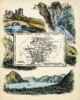
Map, coloured lithograph, Westmoreland ie Westmorland,
scale about 14 miles to 1 inch, copy of the map by R Miller
1810 or by T Crabb 1819, published by Darton and Clark, 58
Holborn Hill, London, 1845-50.
Included in Reuben Ramble's Travels through the Counties of England. The vignettes around the map are of Brough Castle, Stock gill Force, a Slate Quarry, and Ullswater Lake. |
||

|
Ramble 1845 | |
| map feature:- | north point & up is N & scale line & lat and long scales (W of Greenh.) & sea shaded & coast shaded & rivers & lakes & parks & county & wards (? not labelled) & settlements & roads & vignettes | |
| inscription:- |
printed lower right
WESTMORELAND |
|
| scale line:- | 8 miles = 14.7 mm | |
| scale:- | 1 to 880000 ? (1 to 875833 from scale line assuming a statute mile) | |
| wxh, sheet:- | 16x21cm | |
| wxh, map:- | 106x69mm | |