 Miller 1810

|

|
|
|
item:- Armitt Library : ALMC2008.14.52 image:- © see bottom of page |
click to enlarge |
|
|
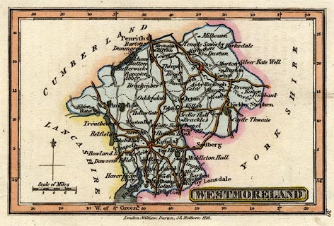
Map, hand coloured engraving, Westmoreland ie
Westmorland, scale about 14 miles to 1 inch, by Robert
Miller, 1810, published by William Darton, 58 Holborn Hill,
London, 1820.
Included as plate 30 in Darton's New Miniature Atlas. There is a sheet of descriptive text, pp.30-31, about the county. |
||

|
Miller 1810 | |
| map feature:- | plain cartouche & north point & up is N & scale line & lat and long scales (rectangular projection; longitude W from Greenwich) & coast shaded & rivers & lakes & parks & county & wards (perhaps) & settlements & roads | |
| inscription:- |
printed lower right
WESTMORELAND |
|
| inscription:- |
printed bottom
London : William Darton, 58, Holborn Hill. |
|
| inscription:- |
printed above scaleline
Scale of Miles |
|
| scale line:- | 8 miles = 14.2 mm | |
| longitude, Kendal:- | 2d 47m W | |
| wxh, sheet:- | 15.5x9.5cm | |
| wxh, plate:- | 120x82mm | |
| wxh, map:- | 105x68mm | |
| scale:- | 1 to 870000 ? (1 to 874546 from scale line wrongly assuming a statute mile) | |
|
|
notes | |