 Blaeu 1645

|

|
|
|
item:- Armitt Library : ALMC2008.14.11 image:- © see bottom of page |
click to enlarge |
|
|
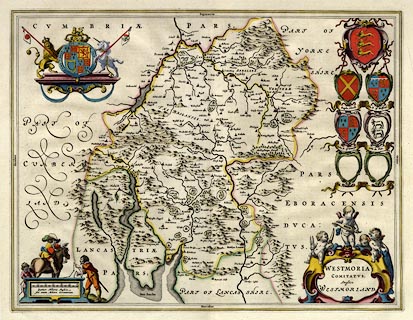
Map, hand coloured engraving, Westmoria Comitatus Anglice
Westmorland, scale about 2.5 miles to 1 inch, by Johann
Blaeu, Amsterdam, Netherlands, 1645, French edition 1663 or
1667.
From la Geographie Blauianae vol.5. There is text in French on the reverse - p.345 the end of Lancashire, and p.346 the beginning of Westmoreland. The same map was used in a series of editions in Latin to about 1662. As well as the royal arms of the Stuart period, there are coats of arms of Raphe Nevill, John Duke of Bedford, John Duke of Somerset, John de Foix, and of England. |
||

|
Blaeu 1645 | |
| map feature:- | scroll cartouche (and cherubs with shuttles and shears) & coat of arms & swash lettering & labelled borders (Latin) & up is N & scale line (the cartouche decoration has a surveyor and assistant using a surveyor's chain) & sea plain & coast shaded & rivers & bridges & lakes & relief & hillocks & woods & forests & parks & county & settlements | |
| inscription:- |
printed title cartouche, lower right
WESTMORIA / COMITATUS; / Anglice / WESTMORLAND. |
|
| inscription:- |
printed below the scale line, lower left
Quatuor Milliaria Anglica / sive unum Milliare Germanicum. |
|
| scale line:- | 6 miles = 60.9 mm | |
| scale:- | 1 to 160000 ? (1 to 158556 from scale line wrongly assuming a statute mile) | |
| wxh, sheet:- | 58.5x50cm | |
| wxh, plate:- | 503x383mm | |
| wxh, map:- | 498x379mm | |
|
|
notes | |