 Blaeu 1645

|

|
|

|
back to object record | |
| MAP FEATURES | ||
|
|
||
|
title
map maker |
A title in Latin and English is printed in a scroll
cartouche, lower right of each map:-
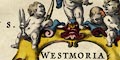
WESTMORIA COMITATUS; Anglice WESTMORLAND. with cherubs carrying weaving implements, shuttles and shears, one holding a piece of cloth. CUMBRIA, Vulgo CUMBERLAND. with a pastoral scene; hills, waterfall, sheep on the fell, cultivating, broadcast sowing. |
|
|
|
||
|
coat of arms
heraldic border |
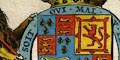
Upper left on each map is the royal coat of arms of the Stuart period, with crest, supporters, motto etc. On the throne in 1645, was Charles I in the middle of the Civil War. Upper right on each map under the arms of England, is a group of coats of arms, a 'heraldic border', each with a caption. Westmorland:- Raphe Nevill John D. of Bedford. John D. of Somerset John de Foix. Cumberland:- Marcatus E. Ran Meschems Andrew Harkley further notes see:- BLA6Arm.txt |
|
|
|
||
|
orientation labelled borders
up is N |
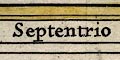
The orientation of each map is shown by labelled borders, in Latin:- Septentriones / Oriens / Meridies / Occidens The map is printed with North at the top of the sheet. |
|
|
|
||
|
scale line
scale |
Printed lower left of each map is a scale.
Westmorland:- 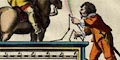
Quatuor Milliaria Anglica sive unum Milliare Germanicum. chequered in quarters, labelled in miles, in a cartouche, illustrated with a gentleman on horseback asking directions of a surveyor with a measuring chain. The 6 miles = 60.9 mm gives a map scale 1 to 158556 wrongly assuming a statute mile. The map scale is about:- 1 to 160000 2.5 miles to 1 inch Cumberland:- Milliaria Anglica quorum quatuor unum Constituunt Germanicum. chequered in quarters, labelled in miles, in a cartouche, illustrated with naiads and cherubs. The 8 miles = 56.9 mm gives a map scale 1 to 226270 wrongly assuming a statute mile. The map scale is about:- 1 to 230000 3.5 miles to 1 inch |
|
|
|
||
|
sea area
sea plain swash lettering galleons |
Little sea is shown on the Westmorland map, on the
Cumberland map the sea areas are plain, labelled:-
MARE HIBERNICUM Anglis THE IRISH SEA partly in swash lettering. The Solway Firth is labelled:- Ituna Bay / Eden fl Two galleons are drawn in the Irish Sea. Each seems to have three masts and a sprit with some sails set others furled; spritsail, fore and fore top sails, main and main top sails, lateen sail on the mizzen mast. |
|
|
|
||
|
coast line
coast shaded headlands harbours foreshore |
The coast line is emphasized by shading. Foreshore sands in the Kent and Leven Estuaries and in the Solway Firth are indicated by dotting. Labelled S of the Cartmel peninsula is:- Ken Sandes On headland is labelled:- St. Bees head and one harbour:- Derwenfote haven N of Workington. |
|
|
|
||
|
rivers
bridges |
Rivers at the lower, broader part are drawn by a double line which might have stream lines, this tapers to a single wiggly line tapering upstream. The River Leven out of Windermere is drawn very broad, as an arm of the sea with coast shading, up to the lake. A few rivers are labelled, eg:- Can flud. [Kent] Wynster flu. [Winster] Burbek flu. [Birk Beck] Trout Bek Darwent fl. The maps have no roads but some bridges are marked by a double line crossing and interrupting a stream. 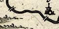
A bridge might be labelled, eg:- Newe Bridge Levens Bridge the latter having not a bridge symbol but a village symbol. |
|
|
|
||
| lakes |
Lakes are drawn in outline with the shore line shaded, the interior dotted. The following lakes are labelled:- Brodwater [Ennerdale Water Denak fl [Devoke Water] Loweswater Thurlemyre Ulles fl Wynander mere flud Other lakes or tarns might be recognized, eg:- Crummock Water Buttermere lake Bleaberry Tarn (very large) Wast Water Bassenthwaite Lake Derwent Water Burnmoor Tarn (?) Coniston Water Esthwaite Water (draining northward) Grasmere lake Rydal Water Grisedale Tarn |
|
|
|
||
|
relief
hillocks silly |
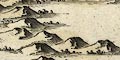
Relief is indicated by hillock shaded to the east, craggy and in various sizes, they are attractive decoration. The hillocks are arranged in groups and ranges but cannot be relied upon as a depiction of the shape of the counties. The Mallerstang Valley is enclosed by hills; the Pennines run down the eastern border; there are mountains in the central Lakes; the Eden valley is flat; ... Some larger hills are labelled, eg:- Fournes fells Helvillon hill Morton Pike Farleton Knothill A small group of hillocks south of Ings is carefully labelled:- 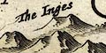
The Inges the label slanted to match the line of hills. Above is the label:- Chapollon for the village of Ings, which is sometimes called Chapel on the Ings. There is no range of hills called Inges. I f you have engravers who s do not speak English and do not know the places in the map, this is the sort of copying error to expect. The copying is probably done from Speed's map, whose engraving of this village name could encourage the mistake. |
|
|
|
||
|
woods
trees forests |
Woodland is indicated by tree symbols. Some of the forest
areas are labelled, eg:-
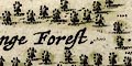
Mallerstang Forest Copeland Forest and some others might be recognized. |
|
|
|
||
| parks |
Parks are drawn by a ring of fence palings, often
enclosing a few trees, and sometimes a building symbol. Some
parks are labelled, eg:-
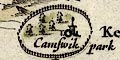
Camswik park [Cunswick] Brigster park others might be named by their great house, as at:- Wharton Hall |
|
|
|
||
|
county
swash lettering |
County boundaries are a dashed line which is continued alongside other boundary features, such as a river. The boundary is emphasized by a tint along the inside for the county and adjacent counties. In one instance the colourist has got carried away in his, perhaps mindless, task and taken the yellow tint for Westmorland up the River Eden too far. Some features on the map are boundary markers, for examples: the County Stone, the stones on Wrynose, etc. On both maps the topography of the northern part of Furness, Lancashire, is shown. Adjacent counties are labelled, eg:- WESTMORIAE PARS. / Part of Westmorland. PART OF YORKE SHIRE. some of this in swash lettering. |
|
|
|
||
| settlements |
Settlements are marked by a circle with added elements,
further differentiated by style of labelling. The nearly
opaque red tint for towns obscures some of the symbols.
|
|
| cities |
circle, town wall, buildings, towers; labelled in upright
lowercase text:-
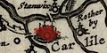
Carlile |
|
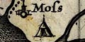
| towns |
circle, buildings and towers; labelled in upright
lowercase text, eg:-
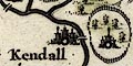
Kendall Penreth Towns etc, see:- |
|
|
villages
hamlets |
circle, building and tower; labelled in italic lowercase
text, eg:-
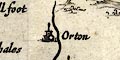
Orton Askham Soulbye |
|
| castles |
circle, towers; labelled in italic lowercase text,
eg:-
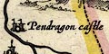
Pendragon castle Daker cast |
|
|
|
||
| miscellany | ||
|
|
||
|
antiquities
tents |
A tent symbol is used to mark a battle. There is one on Sollome Moss ie Solway Moss for the battle of 1542. There is another at Penrith. |
|
|
|
||
|
antiquities
roman wall |
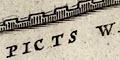
Hadrian's Wall is drawn as a crenellated wall from Boulness ie Bowness, through Carlile, then north and east into Northumberland; labelled:- THE PICTS WALL |
|
|
|
||
| beacons |
On a hillock north of Isel is a post with what look like
rungs, labelled:-
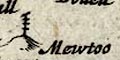
Mewtoo Becon On a hillock ENE of Orton is a post with what could be a cresset, labelled:- 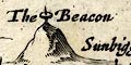
The Beacon |
|
|
|
||
| stones |
On the county boundary N of Grasmere are two tower
symbols on a hillock,labelled:-
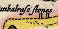
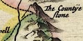
Dunbalrasse Stones [Dunmail Raise Stones] Two standing stones at the meet of three counties on Wrynose are labelled:- Shire stones upon Wernose [Three Shire Stones] At another three county meet, S of Dent, is: The countye stone |
|
|
|
||
| crosses |
A cross on a hillock on the county boundary near
Pendragon is labelled:-
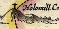
Holomill Crosse |
|
|
|
||
| mines |
Dots, perhaps representing adits, on a hillock by Cladbek
ie Caldbeck, are labelled:-
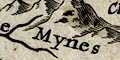
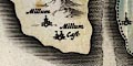
The Mynes On the east side of Derwent Water are two labels:- The mynes Royall Darwen Iland The german miners in Elizabethan times had a base on the island. |
|
|
|
||
|
antiquities
tribal areas |
A label in the Eden Valley east of Carlisle on the
Cumberland map declares:-
BRIGANTES The british tribe in the time of the Romans. On the Westmorland map the same label is engraved SE of Ullswater. |
|
|
|
||
|
antiquities
roman forts roman towns |
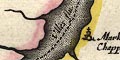
Some roman forts or settlements are labelled:-
CALLAGUM [by Kirkby Thuet / Wellop Cast] ABBALABA [by Appleby] VERTERAE [by Brough] |
|
Lakes Guides menu.