 Blaeu 1645

|

|
|
|
map type:- Blaeu 1645 |
|
|
|
Maps, Westmoria Comitatus or Westmorland, scale about 2.5
miles to 1 inch, and Cumbria or Cumberland, scale about 3.5
miles to 1 inch, by Johann Blaeu, Amsterdam, Netherlands,
1645, published 1645-72.
Published in 'Guil. et Joannis Blaeu. Theatrum Orbis Terrarum sive Atlas Novus. Pars Quarta. Amsterdami, Apud Johannem Blaeu. 1645.' The atlas has a decorated title page, 3 leaves of dedication and 460 pages of text in Latin taken from Camden's Britannia; the maps are copied from those of John Speed and have text on the reverse, Blaeu's name is not on most maps, there is a map of Great Britain and Ireland; the book size is 13 1/2 x 21 ins. The map of Westmorland in the 1645 atlas has coats of arms of England, Raphe Nevill, John Duke of Bedford, John Duke of Somerset, John de Foix, the royal arms , and two blank shields. The map was reprinted in editions -?- Latin, 1645, '48, '62; French 1745, '62; German 1645/46; Dutch 1646/47, '48, '64; Spanish, 1659. For example - in a French edition, 'Le Theatre du Monde, ou Nouvelle Atlas, Mise en lumiere Par Guillaume et Jean Blaeu Quatriesme Partie. Amsterdami, Apud Iohannem Blaeu. MDCXLV.' 1645. For example - in a German edition 'Novus Atlas Das ist Welt-beschreibung mit schoenen newen aussfuehrlichen Land-Taffein in Kupffer gestochen Und an den tag gegeben Durch Wilhelm und Joan Blaeu. Vierter Theil. Amsterdami, Apud Iohannem Blaeu. MDCXLV.' For example - in a Dutch edition 'Tooneel des Aerdrycks, oft Nieuwe Atlas, uytgegeven door Wilhelm en Joan Blaeu. Vierde Deel. Amsterdami, Apud Iohannem Blaeu. MDCXLVI.' in 1646. For example - in a Spanish edition 'Nuevo Atlas del Reyno de Ingalaterra. En Amsterdam A costa y en Casa de Juan Blaeu. MDCLVIIII.' 1659. For example - in a Latin edition 'Geographiae Blavianae Volumem Quintum, quo Anglia, quae est Europae Liber undecimus, continetur. Amstelaedami, Labore & Sumptibus Ioannis Blaeu, MDCLXII.' 1662. Blaeu's works went on fire, 1672, in which all the plates were destroyed. |
||
|
(Westmorland)
|
||
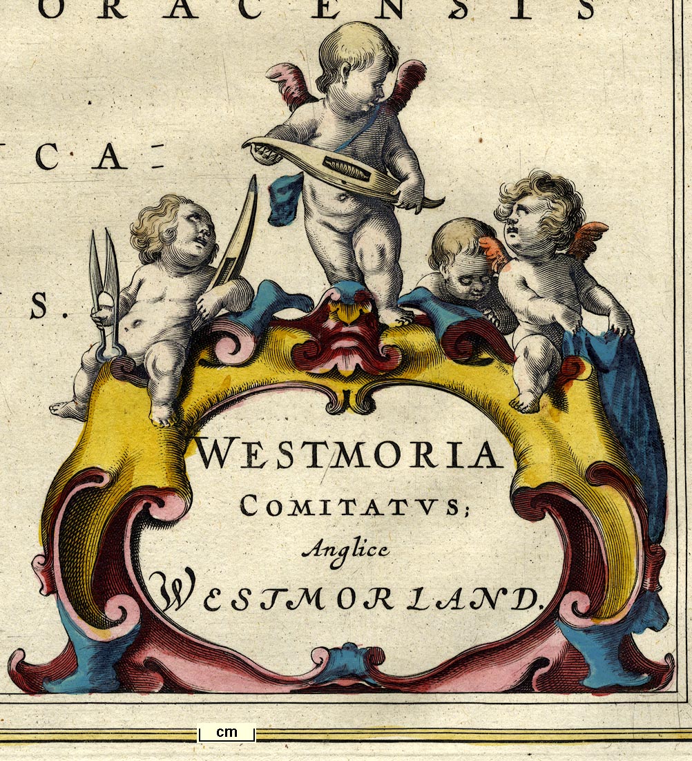
| map feature:- | title cartouche & scroll cartouche & up is N & scale line & coat of arms & heraldic border & sea plain & coast shaded & rivers & lakes & relief & hillocks & woods & trees & forests & parks & county & settlements | |
| inscription:- |
printed scroll cartouche, lower right
WESTMORIA / COMITATUS; / Anglice / WESTMORLAND cherubs with shears, shuttles, and cloth |
|
| scale line:- | 4 miles = 1 5/8 ins | |
| scale:- | 1 to 160000 ? (1 to 155963 from scale line wrongly assuming a statute mile) | |
|
(Cumberland)
|
||
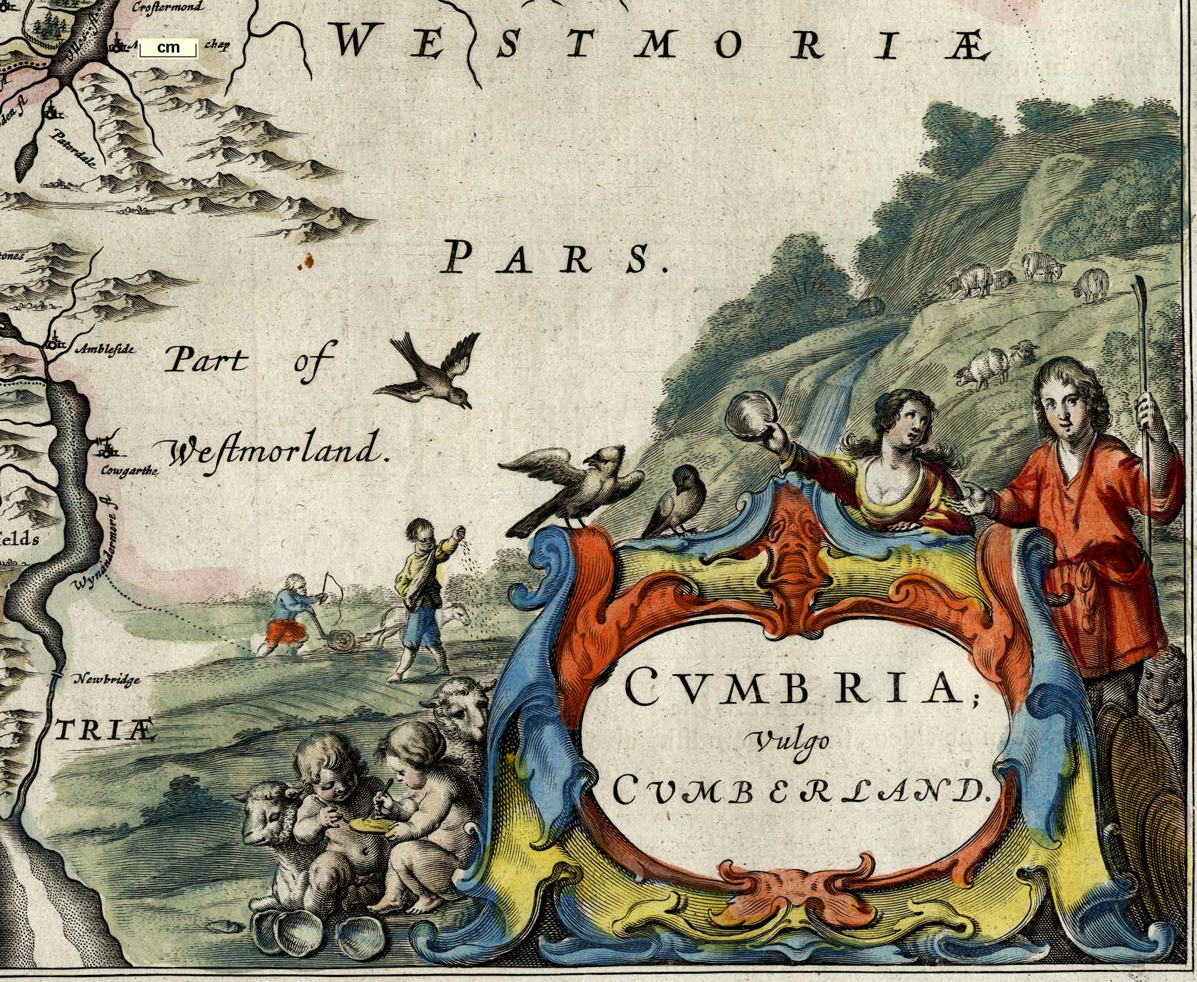
| map feature:- | title cartouche & scroll cartouche & up is N & scale line & coat of arms & heraldic border & sea plain & coast shaded & rivers & lakes & relief & hillocks & woods & trees & forests & parks & county & settlements | |
| inscription:- |
printed scroll cartouche, lower right
CUMBRIA; / Vulgo / CUMBERLAND mountain scene with sheep, ploughing and sowing, etc |
|
| scale line:- | 8 miles = 2 1/4 ins | |
| scale:- | 1 to 230000 ? (1 to 225280 from scale line, wrongly assuming a statute mile) | |
|
||

|
||
| references:- |
Blaeu, William and John: 1645: Theatrum Orbis Terrarum sive
Atlas Novus & Atlas Novus: Blaeu, John (Amsterdam,
Netherlands): part 4 Blaeu, John: 1662: Geographiae Blauianae: Blaeu, John (Amsterdam, Netherlands): vol 5 Blaeu, John: 1663 & 1667: Geographie Blauiane, Contenant L'Angleterre: Blaeu, John (Amsterdam, Netherlands): vol 5 : 1714 & 1715: Atlas Anglois & Description Generale De L'Angleterre: Mortier, David (London) Stevenson, E L: 1914: Willem Janszoon Blaeu: (New York, United States) Wieder, F C: 1929: Monumenta Cartographica: vol.3: (The Hague, Netherlands) Keuning, J: 1959: Blaeu's Atlas: Imago Mundi: 14: pp.74-89 |
|
| sources:- |
Chubb 1927 (LIX) Curwen 1918 Skelton 1970 Hodson 1984 Wordsworth Trust Collection Armitt Library Kendal Library Maps Carlisle Library Maps |
|
| items seen (illustrated items in bold):- | ||

|
Armitt Library : ALMC2008.14.11 -- map -- Westmoria Comitatus Anglice Westmorland -- Westmorland | |
|
|
Carlisle Library : Map 24 -- map -- Cumbria vulgo Cumberland -- Cumberland | |
|
|
Carlisle Library : Map 25 -- map -- Cumbria vulgo Cumberland -- Cumberland | |
|
|
Carlisle Library : Map 55 -- map -- Westmoria Comitatus Anglice Westmorland -- Westmorland | |
|
|
Carlisle Library : Map 56 -- map -- Westmoria Comitatus Anglice Westmorland -- Westmorland | |
|
|
Carlisle Library : Map 349 -- map -- Cumbria vulgo Cumberland -- Cumberland | |
|
|
Dove Cottage : 2007.38.24 -- map -- Cumbria vulgo Cumberland -- Cumberland | |
|
|
Kendal Library : Map 71 -- map -- Westmoria Comitatus Anglice Westmorland -- Westmorland | |
|
|
Kendal Library : Map 72 -- map -- Westmoria Comitatus Anglice Westmorland -- Westmorland | |