 Whellan 1858

|

|
|
|
item:- Armitt Library : A6083.1 image:- © see bottom of page |
click to enlarge |
|
|
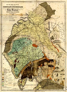
Geological map, hand coloured engraving, Map of the
Counties of Cumberland and Westmoreland including the whole
of the Lake District Geologically Coloured, scale about 3.5
miles to 1 inch, probably by J G Cumming, engraved by W
Banks, Edinburgh, published by W Whellan and Co, Pontefract,
Yorkshire, by Whittaker and Co, London, and by Galt and Co,
Manchester, 1860.
The map is folded and tipped in as frontispiece to The History and Topography of the Counties of Cumberland and Westmoreland, edited by William Whellan. |
||

|
Whellan 1858 | |
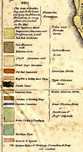
| map feature:- | table of symbols & north point & up is N & scale line & lat and long scales (trapezoid projection?? W from Greenwich) & sea plain & coast form lines & rivers & lakes & relief & hill hachuring & forests & parks & county & settlements & roads & railways & canals & geology & stratigraphical column | |
| inscription:- |
printed upper left
MAP OF THE COUNTIES / OF / CUMBERLAND & WESTMORELAND / INCLUDING THE WHOLE OF THE / Lake District / GEOLOGICALLY COLOURED. / By William Whellan & Co. / 1858. |
|
| inscription:- |
printed bottom, left, right, centre
DRAWN & ENGRAVED BY W. BANKS. EDINR. / Entered at Stationer's Hall / PUBLISHED WITH W. WHELLAN & CO.'S HISTORY AND TOPOGRAPHY OF CUMBERLAND & WESTMORELAND. |
|
| inscription:- |
printed above scale line
Scale of Miles |
|
| scale line:- | 5 miles = 36.8 mm | |
| wxh, folded:- | 20x27cm | |
| wxh, sheet:- | 46.5x61cm | |
| wxh, map:- | 428x585mm | |
| :- | ||
|
||
|
|
notes | |