 Whellan 1858

|

|
|
|
map type:- Whellan 1858 |
|
|
|
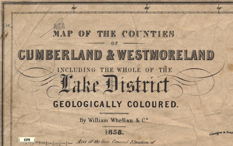
Geological map, Map of the Counties of Cumberland and
Westmorland ... Geologically Coloured, scale about 3.5 miles
to 1 inch, drawn and engraved by W Banks, Edinburgh,
Lothian, published by William Whellan and Co, 1858.
Published in 'THE HISTORY AND TOPOGRAPHY OF THE COUNTIES OF CUMBERLAND AND WESTMORELAND, ... BY WILLIAM WHELLAN. PONTEFRACT; W. WHELLAN AND CO. ... MDCCCLX' 1860. The preface states:- 'an article on the Geology of Cumberland and Westmoreland, with particular reference to the District of the English Lakes, from the pen of the Rev. J. G. Cumming, M.A., F.G.S., Professor of Geology in the Queen's University, Birmingham. From Mr. Cumming's repeated surveys in these districts, and his intimate knowledge of their various strata, he has been able to make many interesting additions to this department of science, and the publishers have no doubt that the Work, with its accompanying Geological Map, will contain a more accurate account of the Geology of the two Counties than any that has yet issued from the press.' Images here are from a map belonging to Threlkeld Mining Museum. A better copy of this map is in the Armitt Museum, folded and tipped in as frontispiece to The History and Topography of the Counties of Cumberland and Westmoreland, edited by William Whellan. |
||
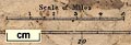
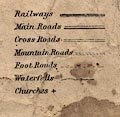
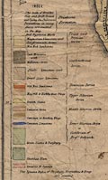
| map feature:- | table of symbols & north point & up is N & scale line & lat and long scales (2d 15m to 3d 38m W; 54d 3m to 55d 11m N) & sea plain & coast form lines & rivers & lakes & relief (minimal) & hill hachuring & settlements & roads (distinguished in the table of symbols as Main Roads, Cross Roads, Mountain Roads and Foot Roads) & railways & canals & geology & table of strata | |
| inscription:- |
printed upper left
MAP OF THE COUNTIES / OF / CUMBERLAND & WESTMORELAND / INCLUDING THE WHOLE OF THE / Lake District / GEOLOGICALLY COLOURED. / By William Whelland and Co. / 1858 |
|
| inscription:- |
printed bottom left
DRAWN & ENGRAVED BY W. BANKS, EDINR. |
|
| wxh, map:- | 423x580mm (approx) | |
| scale line:- | 5 miles = 36.7 mm | |
| scale:- | 1 to 220000 ? (1 to219257 from scale line) | |
|
||
|
||
|
||
| sources:- |
Threlkeld Mining Museum Armitt Library |
|
| items seen (illustrated items in bold):- | ||

|
Armitt Library : A6083.1 -- geological map -- Map of the Counties of Cumberland and Westmoreland including the whole of the Lake District Geologically Coloured -- Cumberland and Westmoreland ... Geologically Coloured | |
|
|
Threlkeld Mining Museum (1) -- geological map -- Map of the Counties of Cumberland and Westmorland ... Geologically Coloured | |