 Hall 1833

|

|
|
|
item:- private collection (25) image:- © see bottom of page |
click to enlarge |
|
|
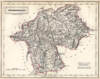
Map, hand coloured engraving, Westmoreland ie
Westmorland, scale about 5 miles to 1 inch, by Sidney Hall,
published by Chapman and Hall, 193 Piccadilly, London, about
1850s.
The map, first published 1833, is probably from the Travelling County Atlas or the New County Atlas by Sidney Hall, as engraved with additions, railways, to the 1840s-50s. |
||

|
Hall 1833 | |
| map feature:- | plain cartouche & north point & scale line & lat and long scales & coast shaded & rivers & lakes & relief & hill hachuring & parks & county & wards (hundreds) & table of wards (hundreds) & settlements & roads & railways & canals | |
| inscription:- |
printed in and below title cartouche, upper left
WESTMORELAND. / ENGRAVED BY S. HALL. |
|
| inscription:- |
printed bottom
London, Published by Chapman & Hall 193 Piccadilly. |
|
| inscription:- |
printed with scale line
English Miles. |
|
| scale line:- | 10 miles = 49.1 mm | |
| scale:- | 1 to 330000 ? (1 to 327769 from scale line) | |
| wxh, map:- | 250x197mm | |
|
|
notes | |