 Hall 1833

|

|
|
|
item:- JandMN (45) image:- © see bottom of page |
click to enlarge |
|
|
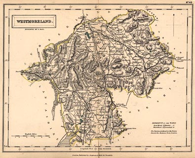
Map, hand coloured engraving, Westmoreland ie
Westmorland, scale about 5 miles to 1 inch, by Sidney Hall,
published by Chapman and Hall, 193 Piccadilly, London, about
1873.
The map, first published 1833, is plate 43 from A Travelling Atlas of the English Counties by Sidney Hall, probably the edition of 1873. |
||

|
Hall 1833 | |
| map feature:- | plain cartouche & north point & scale line & lat and long scales & coast shaded & rivers & lakes & relief & hill hachuring & parks & county & wards (hundreds) & table of wards (hundreds) & settlements & roads & railways & canals | |
| inscription:- |
printed in and below title cartouche, upper left
WESTMORELAND. / ENGRAVED BY S. HALL. |
|
| inscription:- |
printed bottom
London. Published by Chapman & Hall 193 Piccadilly. |
|
| inscription:- |
printed with scale line
English Miles. |
|
| scale line:- | 10 miles = 49.1 mm | |
| scale:- | 1 to 330000 ? (1 to 327769 from scale line) | |
| wxh, sheet:- | 27.5x21cm | |
| wxh, folded (in atlas):- | 13.5x21cm | |
| wxh, map:- | 250x196mm | |
|
|
notes | |