 Hall 1833

|

|
|

|
back to object record | |
| MAP FEATURES | ||
|
|
||
|
title cartouche
plain cartouche map maker engraver publisher |
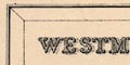
Printed in a plain title cartouche, upper left:- WESTMORELAND. under which is:- ENGRAVED BY S. HALL. Printed at the bottom:- London. Published by Chapman & Hall 193 Piccadilly. |
|
|
|
||
|
orientation
north point up is N |
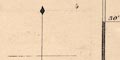
Printed upper right is a north point; N-S line, North marked by an arrowhead, E-S line. The map is printed with North at the top of the sheet. |
|
|
|
||
|
scale line
scale |
Printed lower left is a scale of:-
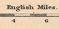
English Miles. chequered at 1 mile intervals, labelled at 2 mile intervals. The 10 miles = 49.1 mm gives a scale 1 to 327769 assuming a statute mile. The map scale is about:- 1 to 330000 5 miles to 1 inch |
|
|
|
||
|
lat and long
lat and long scales |
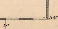
Printed in the map borders are scale of latitude and longitude for a rectangular projection; chequered at 2 minute intervals, labelled at 10 minute intervals. The bottom scale is labelled:- Longitude West from Greenwich The map includes from 2d 4m to 3d 14m West, from 54d 0m to 54d 32m North; all of Westmorland. |
|
|
|
||
|
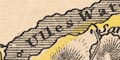
coast line
coast shaded |
The coast line is emphasised by shading. |
|
|
|
||
| rivers |
Rivers are drawn by wiggly line tapering upstream. A few Rivers are labelled, eg:- R. Loyn [Lune, elsewhere labelled Lune] Lowther R. Crowdundle Back R. Mint Bridges are not noticed, but are implied where a road crosses and interrupts a stream. |
|
|
|
||
|
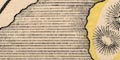
relief
hill hachuring |
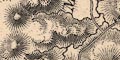
Relief is indicated by hill hachuring which, in its limited way, gives an impression of the massifs of the central fells and the Pennines, and the broad valleys of the Eden and Kent. Some hills are labelled, eg:- Shap Fells Barbon Beacon Helvellin Whitbarrow Scar And some valleys are labelled, eg:- Mardale Patterdale Borrow Dale |
|
|
|
||
| lakes |
Lakes are drawn in outline and shaded, Larger lakes are
labelled:-
Ulles Water Winander Mere Grasmere L. Hawes Water Reservoir [Killington] Elter water Kentmere tarn [not shaded] and some smaller lakes can be recognised, eg:- Rydal Water Brothers water |
|
|
|
||
| forests |
Woodland is not indicated, but some forests are labelled,
eg:-
Milbourn Forest Lune Forest |
|
|
|
||
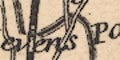
| parks |
Some parks are drawn in outline with fence palings, the
interior dotted. They might be labelled by name or the name
of a house, eg:-
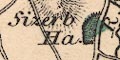
Sizerb Ha. Levens Pa. Dallam Tower Storrs Hall On the map studied the parks are tinted green. |
|
|
|
||
| county |
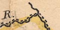
The county boundary is a dashed line. On the map studied the boundary is emphasised by yellow tint. Adjacent counties are labelled, eg:- LANCASHIRE CUMBERLAND A few features are included outwith the county for the sake of continuity, for example Penrith and Sedbergh and the roads to them. Notice the:- County Stone labelled at the meet of 3 boundaries; Westmorland, Lancashire and Yorkshire, in the south east. |
|
|
|
||
|
wards
table of wards |
Wards are comparable to hundreds. The ward boundaries are
a fine dotted line. Ward areas are labelled by number keyed
to a table of wards printed lower right:-
REFERENCE to the WARDS. East Ward ... 1 West Ward ... 2 Kendal Ward ... 3 Lonsdale Ward ... 4 There is a partial boundary around Kendal, a circle and dash line, indicating a special area. 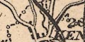
|
|
|
|
||
|
settlements
distances from London |
Settlements are marked by a block or blocks,
differentiated by style of labelling.
|
|
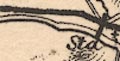
| towns |
group of blocks; labelled in upright lowercase text,
eg:-
Appleby / 270 Shap Ambleside / 278 An exception is labelled in italic block caps:- 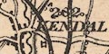
KENDAL / 262 perhaps as the most important town. A note printed lower right declares:- The Figures prefixed to the Towns denote the distance from London. |
|
|
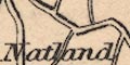
villages
hamlets |
a block or blocks; labelled in italic lowercase text,
eg:-
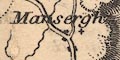
Mansergh Underbarrow Askham The style of lettering is used generally for features on the map, including single houses - not necessarily great houses, eg:- Gill Stone [Kilnstones in Longsleddale] Notice:- Dale End shown as a settlement, 3 blocks either side of the road. |
|
|
|
||
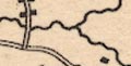
| roads |
A network of roads, or rather routes, is drawn by double lines, in two widths. The broader roads, drawn with light bold lines, are probably turnpike roads. the narrower roads are probably no more than tracks, some rough, for instance the routes over Nan Bield and Gatescarth passes to Mardale. Some road destinations outwith the county are given, eg:- to Barnard Castle from Keswick A few roads are continued out to places beyond the border of the county. |
|
|
|
||
| railways |
Railways are drawn by a bold line, with some stations, outside towns, marked by a cross line. Some railways are labelled. A couple of lines are drawn by a double line with cross ties, perhaps indicating they are planned or in progress of building. It is clear from the engraving, which interfere with existing placename labels and features, that the railways are later additions to the plate. |
|
| Lancaster and Carlisle Railway |
Authorised 1844; opened 1846; labelled:-
Carlisle and Lancaster Railway Bold line. |
|
| Kendal and Windermere Railway |
Authorised 1845; opened 1847.
Bold line; runs to lake shore. |
|
| Ambleside branch railway |
Double line with cross ties; it is possible to seel how
earlier engraving of the line as a continuation of the
Kendal and Windermere branch has been altered. This railway
never happened.
|
|
| Ulverstone and Lancaster Railway |
Authorised 1854, opened?
Bold line. |
|
| Low Gill and Ingleton Railway |
Opened 1859; labelled:-
Nth. Western Ry. Bold line. |
|
| South Durham and Lancashire Union Railway |
Authorised 1857; opened 1861; labelled:-
Northern Counties Union Railway Bold line; an alternative route is shown near Tebay, double line with cross ties. |
|
| Eden Valley Railway |
Authorised 1858; opened 1862.
Bold line; ends at Kirkby Stephen. |
|
| Cockermouth, Keswick and Penrith Railway |
Authorised 1845; opened 1864-65.
Bold line; only a short part near Penrith is drawn. |
|
| Settle and Carlisle Railway |
Authorised 1866, opened 1876.
Double line with cross ties. Only the Mallerstang Valley part is shown; but this might be a planned extension of the Eden Valley railway? |
|
|
The Arnside to Hincaster branch is not shown, nor the
northern part of the Settle and Carlisle railway, both
opened 1876. Leaving aside the Ambleside branch the railways
shown suggest a date for the map after 1858 before 1876, the
edition of the atlas 1873 is a good fit. I do not know what
early dreams there were for an extended railway to
Ambleside, dreams before the suggested date of the map.
|
||
|
|
||
| canals |
Canals are drawn by a triple line, light bold light. The canal shown is:- |
|
| Lancaster Canal |
from the south up to Kendal.
The reservoir shown at Killington feeds water to this canal. |
|
|
|
||
| miscellaneous | ||
|
|
||
| beacons |
A hill on the Yorkshire border is labelled:-
Barbon Beacon |
|
|
|
||
| peat mosses |
An area around Ulpha on the east bank of the Kent Estuary
is labelled:-
Peat Mosses |
|
Lakes Guides menu.