 OS 1922 relief

|

|
|
|
item:- Hampshire Museums : CRH1960.94.9 image:- © see bottom of page |
click to enlarge |
|
|
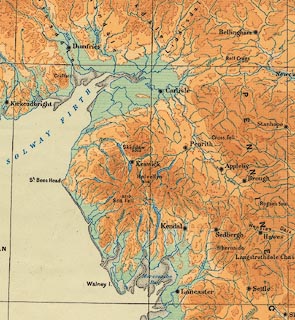
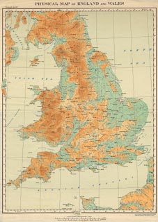
Map, physical map of England and Wales, scale about 16
miles to 1 inch, vertical interval 200ft, published by the
Ordnance Survey, Southampton, Hampshire, 1922.
|
||

|
OS 1922 relief | |
| map feature:- | scale line & lat and long scales (conical projection) & lat and long grid (1 degree intervals) & index grid (using lat and long at 30 minute intervals, I to XVIII, a to n) & settlements (major) & rivers & relief & contours & layer colouring | |
| inscription:- |
printed top
PHYSICAL MAP OF ENGLAND AND WALES |
|
| inscription:- |
printed bottom right
Drawn and Published at the ORDNANCE SURVEY OFFICE, Southampton, / in 1922 by Colonel Sir Charles Close, K.B.E., C.B., F.R.S., Director General. |
|
| inscription:- |
printed above scale line
Scale of 1.014 Inch to Sixteen Statute Miles = 1/1,000,000 |
|
| scale:- | 1 to 1000000 ? (nominal) | |
|
||