 Hinton 1748

|

|
|
|
item:- Dove Cottage : 2007.38.72 image:- © see bottom of page |
click to enlarge |
|
|
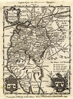
Map, uncoloured engraving, A Correct Map of Cumberland,
scale about 9 miles to 1 inch, by either Emanuel Bowen or
Thomas Kitchin, published by John Hinton, The Kings Arms, St
Paul's Church Yard, London, 1748.
One of a series of maps from The Universal Magazine of Knowledge and Pleasure. |
||

|
Hinton 1748 | |
| map feature:- | baroque cartouche & coat of arms & up is N & lat and long scales & sea plain & coast form lines & rivers & lakes & relief & hillocks & woods & forests & parks & county & wards (hundreds) & settlements & roads | |
| inscription:- |
printed title cartouche, upper left
A / Correct map / of / CUMBERLAND / from the best / Surveys |
|
| inscription:- |
printed bottom
Printed for J. Hinton at The Kings Arms, St. Pauls Church Yard London 1748. |
|
| scale:- | 1 to 580000 ? (estimate) | |
| wxh, sheet:- | 20x24cm | |
| wxh, plate:- | 176x220mm | |
| wxh, map:- | 155x200mm | |
|
|
notes | |