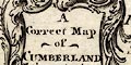
 Hinton 1748

|

|
|

|
back to object record | |
| MAP FEATURES | ||
|
|
||
|
title
baroque cartouche map maker |
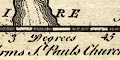
Printed in a baroque cartouche, upper left:-
A Correct map of CUMBERLAND from the best Surveys Printed at the bottom:- Printed for J. Hinton at The Kings Arms, St. Pauls Church Yard London 1748. |
|
|
|
||
| coat of arms |
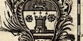
Printed lower left are:- The Arms of Carlisle and lower right:- The Arms of Cumberland, which are the same apart from the surrounding cartouches and shape of shield. |
|
|
|
||
|
orientation
up is NE |
The only indicators of orientation are the lat and long
scales in the map borders. The map is printed with roughly
North East at the top.
|
|
|
|
||
| scale |
The only indicator of scale is the latitude scale in the
map borders. An estimate from these give a map scale
about:-
1 to 580000 9 miles to 1 inch |
|
|
|
||
|
lat and long scales
time from London |
Printed in the map borders are scales of latitude and longitude for a rectangular projection slanted on the page 15 degrees West; chequered in 3 minute intervals, labelled at 15s of latitude; chequered at 2 minute intervals, labelled at 10s of longitude on the lower scale. The map includes from 2d 19m to 3d 47m W, from 54d 7m to 55d 7m N. The upper longitude scale is chequered in 2 minute intervals of time, labelled:- 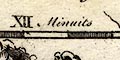
Minuits of Time how much local solar time lags behind London time. Remember that 1 degree longitude corresponds to 4 minutes time. |
|
|
|
||
|
sea area
sea plain |
The sea area is plain. Some sea areas are labelled,
eg:-
THE BRITISH OCEAN [Irish Sea] Solway Firth Ituna Bay [Solway/Eden] |
|
|
|
||
|
coast line
coast form lines headlands foreshore |
The coast line is emphasized by form lines. One headland is noticed:- St. Bees Head Dotted lines in the Solway Firth and the Kent Estuary suggest foreshore sands. |
|
|
|
||
|
rivers
bridges |
Rivers are drawn by a wiggly line tapering upstream. A
broader stream might be drawn by a double line, perhaps with
stream lines, as the lower Derwent and the Eden. Some rivers
are labelled, eg:-
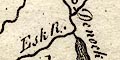
Esk R Leven R [Lyne] Darwent R Some bridges are marked definitely by a double line across a stream, and might be labelled, eg:- 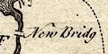
New Bridge [Newby Bridge] and might also be associated with a road as at Eamont Bridge. In other places the association of road and bridge is less exact, as at Thursby. And many roads cross streams without interrupting them; roads seem to have been engraved as an afterthought. |
|
|
|
||
| lakes |
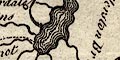
Lakes are drawn in outline with form lines. The following lakes are labelled:- Brodwater [Ennerdale Water] Shurlemire [Thirlmere] Wynandermere Other lakes might be recognized, eg:- Bassenthwaite Lake Bleaberry Tarn Brothers Water Burnmoor Tarn Buttermere lake Coniston Water Crummock Water Derwent Water Devoke Water Esthwaite Water Loweswater lake Rydal Water / Grasmere lake [drawn as one] Ullswater Wast Water |
|
|
|
||
|
relief
hillocks |
Relief is mostly ignored, but hillocks shaded to the east
are used on Stainmore, the Scottish border, and to mark a
few hills, eg:-
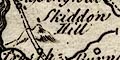
Skiddow Hill [a larger hillock] Dent Hill Hardknot |
|
|
|
||
| forests |
Groups of tree symbols mark some forest areas, labelled,
eg:-
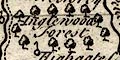
Inglewood forest W. Ward Forest Copland Forest |
|
|
|
||
| parks |
A park might be drawn by a ring of fence palings, perhaps
labelled, eg:-
Barwood Park or by house name, eg:- 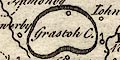
Grastock C. |
|
|
|
||
| county |
County boundaries are a dotted line which may or may not be carries on alongside a boundary feature. Cumberland includes part of Ullswater; part of Windermere lake is included in Lancashire. Adjacent counties are labelled, eg:- PART OF WESTMORLAND Some rivers, some relief, and roads, are shown outwith the county for the sake of continuity. Notice in particular the mountains of Westmorland and Eden and Eamont rivers. |
|
|
|
||
|
wards
table of wards |
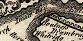
Ward boundaries are a dotted line. The ward areas are labelled with a letter referring to a table printed lower right:- The Names of ye Divisions A. Cumberland B. North Allerdale C. South Allerdale D. Leath Ward E. Eshdale Ward |
|
|
|
||
| settlements |
Settlements are marked by a circle with added elements,
further differentiated by style of labelling.
|
|
|
cities
electoral data |
circle, buildings, tower; labelled in upright block
caps:-
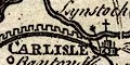
CARLISLE which also has a cross for its church, and a star for a member returned to Parliament. |
|
| towns |
circle, buildings, tower; labelled in upright lowercase
text,e G;-
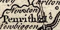
Penrith Kirk Oswald |
|
|
villages
hamlets |
circle; labelled in italic lowercase text, eg:-
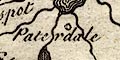
Paterdale Aspatrick Unthank This symbol and style of lettering is used for other features such as:- Chappel of ye Grune and there might be an added cross as at:- Leonard Coast [Lanercost] |
|
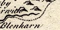
| castles |
circle, post and flag; labelled in italic lowercase text,
eg:-
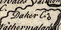
Daker C. There might be no label, as at Penrith Castle. There is confusion between abbreviations C of Chapel or Church, and C for Castle. This has confused the map maker at least once where |
|
|
Wasdale C.
St Olaf's Wasdale Head, has a circle with post and flag for a castle. |
||
|
|
||
| roads |
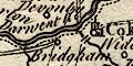
Roads are drawn by a double or single line. The roads shown are:- double line from Westmorland, labelled 'to Dalerston Br.'; over Eamont Bridge, through Penrith, Hesket, Carleon, to Carlisle, Cumberland. double line labelled 'to Kendal' through Ambleside, Westmorland; then Woborn, Thurlspot, a bridge over the beck from Shurlmire [Thirlmere], Keswick, over the Greta missing the bridge! Crosthwait, Bassignwat, Armathwate, ending at a bridge over the Derwent, Cumberland AND double line branch from near Ouse Bridge to Cokermouth, Cumberland. double line from the north side of the Derwent by Cokermouth (no bridge shown), through Blenerhasset, near Wigton, over the Wampool by a bridge, Thursby, to Carlisle, Cumberland AND alternative route, single line from the north side of the Derwent by Cokermouth, through Ierby, Castra Explor, to the bridge across the Wampool. double line from Egremond through Whithaven, Morosbye, Workinton, to Bridgham, Cumberland AND alternative route, single line by a bridge over the Ehen to Bridgham, Cumberland. single line, over the Coker by a bridge, to Cokermouth, Cumberland. double line from Carlisle, across the Eden by a bridge, near Longtown, Cumberland, to the Kirksop R., no bridge; into Scotland, labelled 'to Barwick'. double line from Carlisle, across the Eden at Corby, no bridge, ignoring the bridge at Warwick, then Castle Carok, Forlam, Cumberland; into Northumberland, labelled 'to Newcastle upon Tyne'. |
|
|
|
||
| miscellany | ||
|
|
||
|
antiquities
roman wall |
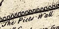
Hadrian's Wall is drawn by a bold line with crenellations. from Boulness, through Carlisle, then north and east into Northumberland, labelled:- The Picts Wall |
|
|
|
||
|
antiquities
tents battle sites |
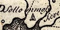
On Sollom Moss is a tent symbol for the Battle of Solway Moss, 1542. |
|
|
|
||
|
mines
copper mines |
Labelled beside Derwent Water is:-
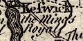
The Mines Royal The german miners in elizabethan times lived on Derwent Isle. |
|
|
|
||
| stones |
Two standing stones on the county boundary are
labelled:-
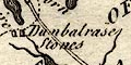
Dunbalrase Stones |
|
Lakes Guides menu.