 Hinton 1748

|

|
|
|
map type:- Hinton 1748 |
|
|
|
Maps, Correct Map of Cumberland, scale about 9 miles to 1
inch, and of Westmorland? by Emanuel Bowen or Thomas
Kitchin, London, 1748.
Published in 'The Universal Magazine of Knowledge and Pleasure: Containing ... And Other Arts and Sciences; Which may render it Instructive and Entertaining To Gentry, Merchants, Farmers, and Tradesmen. ... Published Monthly according to Act of Parliament, By John Hinton, at the King's Arms in St. Paul's Church-Yard, London.' Maps in the magazine, included in issues from 1747-66, were drawn by Bowen, Kitchin and Seale, either Bowen or Kitchin drew this map. The Cumberland map has coats of arms of Carlisle and Cumberland. |
||
|
(map example Dove Cottage : 2007.38.72)
|
||
| map feature:- | baroque cartouche & coat of arms & up is N & lat and long scales & sea plain & coast form lines & rivers & lakes & relief & hillocks & woods & trees & forests & parks & county & wards (hundreds) & settlements & roads | |
| inscription:- |
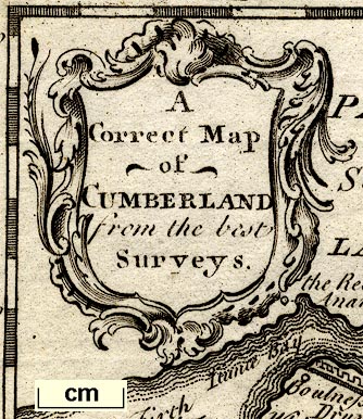
printed title cartouche, upper left
A / Correct map / of / CUMBERLAND / from the best / Surveys |
|
| inscription:- |
printed bottom
Printed for J. Hinton at The Kings Arms, St. Pauls Church Yard London 1748. |
|
| wxh, sheet:- | 20x24cm | |
| wxh, plate:- | 176x220mm | |
| wxh, map:- | 155x200mm | |
| scale:- | 1 to 580000 ? (estimate) | |
| references:- |
: 1750: Universal Magazine of Knowledge and Pleasure:
Hinton, John (London) |
|
| sources:- |
Chubb 1927 (CLXXXVIII) Hodson 1984 Wordsworth Trust Collection |
|
| items seen (illustrated items in bold):- | ||

|
Carlisle Library : Map 6 -- map -- Correct Map of Cumberland | |
|
|
Carlisle Library : Map 325 -- map -- Correct Map of Cumberland | |
|
|
Dove Cottage : 2007.38.72 -- map -- Correct Map of Cumberland | |