 Whittaker 1821

|

|
|
|
item:- Dove Cottage : 2007.38.55 image:- © see bottom of page |
click to enlarge |
|
|
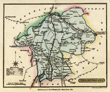
Road map, hand coloured engraving, Westmoreland, scale
about 9 miles to 1 inch, engraved by Neele and Son, 352
Strand, published by G and W B Whittaker, Ave Maria Lane,
London, 1821-23.
From The Travellers Pocket Atlas Consisting of A Complete Set of County Maps, For England and Wales. |
||

|
Whittaker 1821 | |
| map feature:- | plain cartouche & table of symbols & compass rose & up is N & scale line & sea plain & coast form lines & rivers & lakes & parks & county & settlements & roads & road distances | |
| inscription:- |
printed title cartouche, lower right
WESTMORELAND |
|
| inscription:- |
printed bottom right, centre
Neele & Son sculpt. 352 Strand. / Published by G. & W. B. Whittaker, Ave-Maria Lane, 1821. |
|
| inscription:- |
printed above scale line
Scale of Statute Miles. |
|
| scale line:- | 10 miles = 29.0 mm | |
| scale:- | 1 to 550000 ? (1 to 554946 from scale line) | |
| wxh, sheet:- | 19x14.5cm | |
| wxh, map:- | 159x128mm | |
|
|
notes | |